Welcome to the Encyclopedia of Saskatchewan. For assistance in exploring this site, please click here.
By: Brian Cousins
The vastness of Saskatchewan’s land-locked prairie, woodlands and Precambrian Shield has always created transportation challenges. Transportation has been a critical social, economic and political issue for the region—demanding innovation and fueling controversy. Well before European settlement in what became Saskatchewan, the region’s indigenous peoples witnessed particular changes that dramatically affected the nature and quality of their life. Spain’s introduction of horses to the Americas in the 16th century had extended to the Saskatchewan plains by the mid-18th century, probably achieved through contact and trade with indigenous peoples to the south and possibly aided by the emergence of bands of feral horses that spread through many areas of North America. Horses came to replace dogs in helping to meet the transport requirements of the prairies’ nomadic First Nations, who met subsistence requirements by pursuing buffalo and other game.
The introduction of the Fur Trade, particularly in the northern half of Saskatchewan, introduced a new concept of commerce among First Nation peoples and created new transportation requirements for harvesting fur and delivering it to markets via distant trading posts. The arrival of railroads led to the single greatest transformation of the southern half of the province by facilitating an era of mass immigration and agricultural cultivation. When Red River Carts gave way to trains, waves of immigration brought settlers from Europe to create farms and communities across the prairie. In the process, much of the traditional lifestyle of the region’s indigenous peoples was compromised.
The combination of a widely dispersed agricultural economy and the introduction of assembly-line production and lower costs for automobiles and trucks made Saskatchewan an instant market for the new horseless carriages. They were put to use on what would become Canada’s largest network of highways and roads, building on the trails of indigenous peoples and early settlers. By 1957, Saskatchewan had one registered vehicle for every 2.7 residents, well above the national ratio of one to 3.7.
After the advent of commercial Aviation, aircraft soon appeared in Saskatchewan. A Saskatchewan-based plane was the first licensed commercial aircraft in Canada, and Regina resident Roland Groome became the nation’s first licensed commercial pilot.
Aerial photography surveys were initiated by the Royal Canadian Air Force (RCAF) in 1924, the year it was formally created. The surveys and new accessibility (made possible by aircraft) sparked increased mineral exploration and development in northern Saskatchewan. During the years of World War II, Saskatchewan was home to more than twenty aviation training schools under the British Commonwealth Air Training Plan (BCATP). In 1946, the first air ambulance service in the Commonwealth and North America was established in Saskatchewan. The following year, the service had three aircraft: a Norseman, a Stinson and a Fairchild Husky, the latter being Canada’s first commercially operated aircraft licensed and fitted to use jet propulsion. Aircraft also added an important dimension to forest fire detection and suppression: in 1947 Saskatchewan pioneered the use of “smokejumpers,” firefighters who were parachuted into newly discovered fires to stop them from spreading.
The province’s reliance on railroads increased as potash resources were developed across the central grain belt of Saskatchewan from the 1950s through to the 1970s. Potash production, virtually all of which is transported by railcars, grew to more than 8 million tons each year—still well short of the annual grain haul (which averages more than 22 million tons), but a major growth factor for railway transportation in Saskatchewan and for the province’s mineral sector.
However, railway economics and policies were not all expansionary. In the last half of the 20th century passenger services were severely reduced—a result of less demand but also a reflection of the railroads’ primary interest in profiting from freight hauling. Then, in search of lower-cost, higher-efficiency grain transportation, new words were introduced to the prairie lexicon: “inland grain terminals” (dramatically reducing reliance on community-based elevators) and “rail line abandonment” (shifting grain transport increasingly to trucks and the road system), creating a new era of agricultural transportation demands and issues. For many decades, grain transportation has been a topic of heated debate—in the provincial Legislature, in the national Parliament, and in the coffee shops and kitchens in hundreds of Saskatchewan communities. The “Crow Rate” agreement, the use of the Hudson Bay Port of Churchill, the demise of community elevators (and sometimes of the communities themselves), and the role of independent short-line rail services remain common topics of discussion in family and community forums across the plains.
Even when rail passenger service was at its zenith in Saskatchewan, it did not fully meet the needs for inter-community passenger and freight services in the province. As a result, the Saskatchewan Transportation Company (STC) was created as a provincial bus service in 1946; in 2004, the provincially subsidized Crown corporation continued to serve 275 Saskatchewan communities with a fleet of 41 buses.
Beyond the Canoes and York Boats of the fur trade, Saskatchewan’s use of water transport briefly included participation in the era of steam-powered riverboats. But riverboats, together with most passenger train services and the streetcars and electric trolley coaches of Saskatchewan’s larger cities, are no more. Today’s transportation priorities are largely focused on coping with the growing number of automobiles and trucks (there were more than 750,000 vehicles registered in Saskatchewan in 2004), ensuring adequate air services, and developing alternative rail facilities to transport rural grain production. The federal government has largely divested its operation of transportation services in Saskatchewan. The only rail passenger service is Via Rail’s national route, which passes through Saskatchewan via Melville and Saskatoon. Navigational aids and docks have been discontinued on northern waterways. Airports are now a municipal, provincial, or private responsibility; however, air traffic continues to increase with major expansions made to air terminal facilities by municipal airport authorities in both Saskatoon (2003) and Regina (2005).
No single account can fully document the transportation challenges that confronted Saskatchewan people as they developed an economy and population dispersed over vast distances. However, the following summaries and individual entries provide a brief but colourful overview of transportation in the province.
The canoes of indigenous First Nations were common in many regions of Canada including northern Saskatchewan, where the Cree and Dene used them for travel along a vast network of waterways. Canoes were the region’s primary means of seasonal transport when lakes and rivers were free from ice. The early European explorers, fur traders and settlers soon took to using canoes, the speed and agility of which had been acknowledged by Samuel de Champlain as early as 1603, upstream on the St. Lawrence River. The larger birch-bark canoes typically used by voyageurs throughout Canada measured almost eight metres in length and at least a metre in beam, held cargo of up to 1,400 kg, and required five to seven paddlers.
The use of canoes by the voyageurs of the fur trade gave the merchants of Montreal and the fledgling North West Company (NWC) an advantage over the Hudson’s Bay Company (HBC): it allowed them to go inland to meet trappers instead of expecting them to travel great distances to their posts. The HBC soon responded by developing inland posts, including Cumberland House in 1774 and Ile-à-la-Crosse in 1776—the first non-indigenous settlements within the borders of what was to become Saskatchewan.
Early in the 1800s, the HBC also designed and manufactured York Boats. Though more cumbersome on portages than canoes, the 12-metre boats, first made at the company’s York Factory post, had definite advantages: they could carry twice the cargo of a large canoe, and they could use a sail when crossing lakes if wind conditions were right. They became particularly common on the Saskatchewan River system and were used until the early 1900s, complementing the more agile service of canoes.
The major fur trade routes of Saskatchewan were the Churchill, Athabasca and North Saskatchewan River systems. Two of the most widely known and well-used portages that linked together all three of these watersheds are located in northern Saskatchewan: on the west side of the province the Methy Portage connects Lac La Loche to the Clearwater River and the Churchill and Athabasca watersheds; on the east side of the province the Frog Portage connects the Sturgeon Weir and North Saskatchewan River systems to the Churchill watershed. Combined, these two portages form an integrated system of overland linkages that enabled travelers to follow water routes from the prairies all the way to the Arctic Ocean. The fur trade and European exploration went hand in hand. People such as Henry Kelsey, Samuel Hearne and David Thompson—among the first Europeans to journey through Saskatchewan and make contact with the area’s Aboriginal peoples—are now better remembered for their exploration and early mapping than for their service to the companies of the fur trade.
Canoes were not commonly used by First Nations people inhabiting the plains for obvious reasons. A land without birch or pitch, essential to build and maintain a traditional canoe, would not support the development and use of such a craft. As well, the waterways of the plains were generally slower-moving and unbearably long because of the many twists and turns carved out of the land by this slow-moving water. This usually meant that for the more southerly plains, ground transport was much faster than traveling by water. Plains Indians, however, did use temporary “bull boats” for crossing rivers and for downstream travel on fast-flowing rivers. A bull boat could be created in a few hours by sewing buffalo skins onto a frame of bent willow branches. However, flat-bottomed boats have won their place in Saskatchewan’s transportation history: scows and skiffs, usually hand-made, became common in many areas of the province—particularly in the north, where they have long been a mainstay of commercial fishing operations.
HBC records describe a particular attempt in 1869 to revive river transport (as an alternative to using cart trails) as part of the fur trade on the Saskatchewan plains. A fleet of flat-bottomed boats was built at Fort Qu’Appelle out of poplar planks, using spruce gum and buffalo grease as a seal. A difficult six-week journey to Fort Ellice (on the Assiniboine River just across the contemporary border with Manitoba) left the crews disheartened and much of the cargo damaged: the experimental voyage was over and not attempted again.
In August 1874, the newly constructed Hudson’s Bay Company SS Northcote completed its maiden voyage from Grand Rapids, near Lake Winnipeg, to Carlton House on the North Saskatchewan River: a total distance of 790 km (490 miles) upriver via Cumberland House and Prince Albert. It was the beginning of an ambitious but troubled new era in western Canadian transportation. The following year, service was extended to Edmonton; after 1877 the Northcote was modified to include passenger cabins, eventually accommodating as many as fifty people. The largest riverboat to ply the Saskatchewan River waters was the Marquis (built for the Hudson’s Bay Company in 1882), with a length of 67 metres (207 feet).
A particularly dramatic use of steamboats occurred during the North-West Resistance of 1885. Several of the paddle wheel boats were commandeered by the military to transport troops in the campaign against Chiefs Poundmaker and Big Bear. The HBC’s Northcote was used as a gunboat in the battle of Batoche, but was disabled in its first day of combat when Métis forces critically damaged the smokestacks and wheelhouse by lowering a ferry cable across the river. The Northcote’s military career included transportation of wounded militia from the battlefield at Batoche to a field hospital at Saskatoon. The steamboat was also used to transport Louis Riel to Saskatoon before he was taken by land to Regina, where the Métis leader was imprisoned until his trial and subsequent execution.
Other companies followed the HBC lead and used steamboats on both the North and South Saskatchewan rivers. However, the development of rail transport and the continuing problems of shifting sandbars and shallow waters would limit the lifespan of steamboat transport in Saskatchewan. The HBC ended its use of steamboats in 1896. Ten years earlier, the Northcote had been beached at Cumberland House; it never sailed again but disintegrated over the years, remnants of its boilers now serving as an historic site in the community. The last steamboat service to Saskatoon was in 1908, when the City of Medicine Hat hit a traffic bridge and capsized. Smaller vessels continued to ply the waters of Last Mountain Lake until 1913, and on the Carrot River steamboats pulled logs to sawmills as recently as 1954.
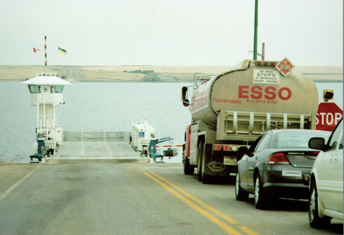
Two other forms of non-recreational use of water transport continue in Saskatchewan, though to a much lesser extent than in earlier years: river crossing ferries and barge shipping on northern waterways. As of 2004, twelve seasonal river ferries were operated by the Saskatchewan Department of Highways and Transportation. Each can hold up to six ordinary-sized vehicles, except for a larger ferry near Riverhurst that can take fifteen cars in a single crossing. At its peak in the early 1950s, Saskatchewan’s ferry fleet totalled 36; many were manufactured in the province by the Highways department.
New bridge construction steadily reduced reliance on ferry service. One of the longest running ferry sites, located on the Battleford Trail, was established at The Landing (north of Swift Current) on the South Saskatchewan River in 1883. It continued until 1951, when construction of a major new bridge was completed. In contrast, the latest ferry service was introduced at Buffalo Narrows in 1957 when the first all-weather road to the northwest Saskatchewan community was completed. Northern ferry services at Buffalo Narrows and Cumberland House were among those that were discontinued when bridges were constructed. However, further north, commercial water transport continues. Under contract with the provincial Highways department, the Hatchet Lake First Nation provides seasonal barge transportation service to the community of Wollaston Lake in northeastern Saskatchewan. Commercial barge services based near Fort McMurray in Alberta used to be the primary means of shipping heavy goods to communities on Lake Athabasca; construction of a seasonal road to the lake in 1999–2000 changed the pattern of shipping to Saskatchewan’s most northerly region. Nevertheless, limited barge service continues to be provided on Lake Athabasca by private firms. A number of “Ice Roads” are also constructed each year across northern lakes; they are particularly important for shipping supplies to the communities of Wollaston Lake and Fond du Lac.
As with canoes and York boats, the use of dog teams was an essential means of transport in support of the northern Saskatchewan fur trade. Some studies suggest that the use of dog teams originated in Siberia 4,000 years ago and spread to the Inuit peoples of North America and then to other northern First Nations. In addition to pulling winter sleds, dogs would also carry packs on their backs. The use of dogs for transportation predates the fur trade, but new breeds were introduced after European contact. The earliest “royal mail” services, initiated in what was then the North-West Territories, included use of dog teams for winter transport. Long distances covered by “dog trains” included the trek from Fort Garry to Fort Pelly, Fort Carlton, and on to Edmonton.
The use of dog teams for trapping and for travel between northern Saskatchewan camps and communities was a primary means of northern winter transportation; but it faced sudden decline during the 1960s and 1970s. Though large track-driven snowmobiles had been introduced in the 1940s, their use was largely confined to industry and government. It was the introduction of smaller “snow machines,” gasoline-powered with skis and tracks (first manufactured by companies such as Polaris and Bombardier in the late 1950s), that won quick acceptance as an alternative to dog teams in meeting the transportation needs of northern trappers. Snowmobiles continue to be a primary transportation vehicle for trapping and commercial ice fishing in northern areas. They also became immensely popular for recreation purposes across the province. Dog teams remain part of the northern Saskatchewan culture; however, today the teams are raised primarily for racing or as a hobby.
Dogs were also a primary means of transportation for the Plains Indians. An A-frame shaped Travois (usually measuring about 2.5 metres in length and one metre at the base) was harnessed to the dog’s back; the natural spring of the tree trunks, used for the frame, allowed the travois to slide over mud, grass, stones or snow. Dogs also helped hunting parties by driving deer and buffalo towards waiting hunters and by forcing buffalo over cliffs or into pounds. Although the arrival of horses by the mid-1700s reduced dependence on dogs, travois continued to be used extensively into the mid-1800s. The concept of the dog travois was also adapted to fit horses prior to the introduction of wagons.
The advent of horses significantly enhanced the mobility of the migratory Plains people in pursuing buffalo and other game: horses could more readily carry lodge poles and heavier loads of food, clothing and supplies. The first European to describe horses on the Canadian plains was Anthony Henday, believed to the first White man to cross the prairies: in 1754 he described the Indian horses as “fine tractable animals, about 14 hands high; lively and clean made.” As the accepted definition of a horse required it to be over 15 hands high, the original Indian horses of the plains must be considered ponies.
A number of routes had been established by First Nations in relation to inter-tribal contact between the Missouri and Saskatchewan river systems. However, formal trails associated with horse-driven carts and wagons emerged more clearly during the introduction of the fur trade and European settlement. Many trails were created to connect major trading posts, forts or stations of the North-West Mounted Police as well as a number of church missions. Some trails involved payment of tolls—typically 25¢—to private land owners, who provided short cuts around bogs or mud holes, or who had constructed wooden bridges. It was the location of rail lines in the late 1800s and early 1900s that would define transportation patterns and the location of hundreds of grain elevators and communities across the southern half of Saskatchewan. But before the railways could carry new settlers to their homesteads, the network of trails which had been created in the province served as the main transportation routes that would lead to the transformation of the natural prairie to farmland.
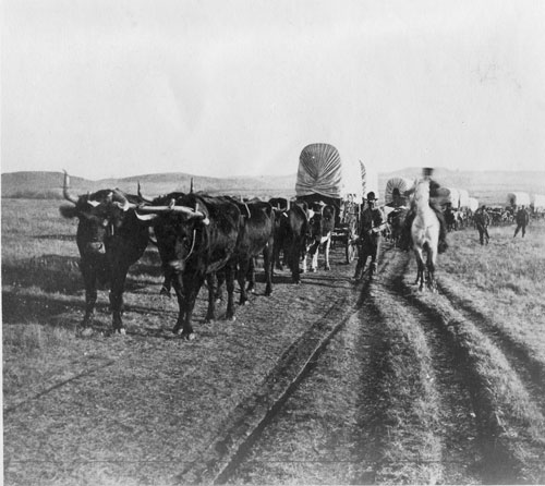
Many of the early settlers who used those trails during the 19th century traveled to Saskatchewan in Red River carts—made popular by the Red River colonists who had established what was, at the time, the most westerly “settlement” in Canada in southern Manitoba. Before the arrival of steamboats and the railways, as many as 2,500 of the carts, with their large wooden wheels and wooden axles lashed to a horse, mule or ox, would bring newcomers to the plains of Saskatchewan each year. In the 1870s, a Red River Cart could be purchased in Winnipeg for between $10 and $15; pulled by oxen, it would average about 15 miles per day while horse drawn carts could travel 15 to 25 miles.
Another key influence in determining the eventual road structure of the southern half of the province was the “grid” system of surveying the land. After the Rupert’s Land Act of 1870 was passed by the federal government, transferring land from the Hudson’s Bay Company to Canada, surveyors began their work on the plains west of Manitoba in 1873. The survey system and grid structure were patterned after similar work in the western United States, ensuring provisions for road access to the thousands of family farms that were created on the prairies. Over time, the provincial and rural municipality road system would expand to over 190,000 km of highways, grid roads and farm access roads—the largest road network of any province in Canada. Initially, all roads in Saskatchewan were considered a municipal responsibility. It was not until 1912 that the provincial government appointed a Board of Highways Commissioners to plan a provincial highway system; the first Department of Highways followed in 1917.

Provincial legislation initiated licensing of Saskatchewan vehicles in 1906 when just 22 vehicles were registered in the province. The legislation also set speed limits: 10 miles per hour in cities, and 20 miles per hour elsewhere. By 1911, there were 821 registered vehicles located in 136 different communities. That year, a Ford Model T Touring Car sold for $1,025; only six years later, mass production of the vehicles reduced the price to $545, causing a surge in demand. The demand for vehicles in Saskatchewan, as well as anticipated population growth, led to the establishment of a General Motors assembly plant in Regina in 1928.
There were two eras when the expansion of vehicle use was briefly stalled: the Great Depression saw the number of vehicles registered in Saskatchewan decline from 128,000 in 1929 to 91,000 in 1934; during World War II production of new automobiles, trucks and tires for domestic use was restricted, and fuel rationing was implemented. During the Depression years, “Bennett Buggies” became common in Saskatchewan and elsewhere. Derisively named after Prime Minister R.B. Bennett, automobiles pulled by horses were used by farmers too impoverished to purchase gasoline. “Black top” and “pavement” were added to the vocabulary in the 1930s when hard surfaced roads were first introduced. But for most areas, the attainment of adequately graded and graveled roads was the more important objective: by 1931, fewer than 3% of farms had gravel road access, and in 1944 Saskatchewan had only 222 km of hard surfaced roads. It was not until the 1950s that the provincial government would support municipalities in undertaking a massive upgrade of Saskatchewan’s grid road system and begin a more significant introduction of pavement across the province.
The largest stretch of black top built in Saskatchewan was the Trans-Canada Highway, begun in 1950 and completed seven years later. Saskatchewan became the first province to complete its section of the national highway, originally cost-shared with the federal government and constructed to agreed standards nationwide. The original Saskatchewan portion of the highway was 653 km in length; it reduced the border-to-border driving distance by 89 km and eliminated 23 level railway crossings. The first “four-lane” highways in Saskatchewan were completed in 1961 from Regina to Lumsden and Regina to Balgonie. The first highway “cloverleaf” interchanges were opened in 1967: one in Regina at the junction of Highways 1 and 6; the second in Saskatoon at the intersection of Highways 11 and 14. Roads north of Meadow Lake, Prince Albert and Nipawin developed much later than in southern Saskatchewan; many were initially constructed as “resource access” roads by the provincial Department of Natural Resources during the 1940s and 1950s.
Before the advent of northern highways, horse and tractor-drawn “trains” were used to haul supplies by sleds to many northern communities during winter. In addition to its southern bus service, for a period of several years the Saskatchewan Transportation Company was also responsible for organizing northern tractor trains to haul supplies to communities such as Montreal Lake, Lac La Ronge and beyond. From 1947 to 2000, three northern road spines (central, west, and east) were developed. A fourth northern highway to the province’s first settlement of Cumberland House was completed in 1967. The central highway to La Ronge was completed in 1948, pushing further north in stages to Missinipi, then to Southend and Points North, on the western shore of Wollaston Lake. In 2000, a seasonal (primarily winter use) road was constructed to Stony Rapids on the southeast shore of Lake Athabasca. Road access to the northwest reached Buffalo Narrows in 1956 and La Loche by 1963. The “Semchuk Trail” was completed in 1979 to serve the then new uranium mine site at Cluff Lake; the road was named after Martin Semchuk, who used to build winter ice roads through the area and across Lake Athabasca to Uranium City.
In the northeast, the Hanson Lake Road between Smeaton and Creighton (on the border with Flin Flon, Manitoba) gained highway status in 1964. Spurs were built to the Churchill River communities of Pelican Narrows in 1967 and Sandy Bay in 1972; road access to Deschambault Lake was added in 1974. Today, the northern highways network remains a work in progress, with new roads continuing to be planned and developed. As of 2004, the provincial Highway Network extended more than 26,000 km, with 20,500 km surfaced and 1,100 km of divided, four-lane highways. By 2004, the Trans-Canada Highway had been “twinned” from Grenfell in the east to the Alberta border; the easternmost end of the highway’s twinning will be completed by 2007.
Saskatchewan’s highways (see Highway Network) serve many purposes. Providing access to communities, industry and farms is more demanding than elsewhere in Canada because Saskatchewan residents are more widely dispersed: more than half of the population lives in communities under 20,000 (as per the national census of 2001). Key east-west and north-south trade corridors are necessary to support economic diversification and expansion, and to permit Saskatchewan’s export-driven economy to maintain efficient access to markets. Throughout the grain belt, massive increases have occurred in the volume of grain hauled by truck to inland terminals, permitting producers to take advantage of the lower grain-loading charges assessed by the railroads because of the efficiencies offered by such terminals. Another demand placed on Saskatchewan’s road network is the sheer volume of traffic: the number of motor vehicles registered (to say nothing of out-of-province trucking and tourism traffic) more than doubled from the 1960s to the 1990s. As of 2004, there were more than 750,000 licensed vehicles and 115,000 licensed trailers registered in the province.
The Canadian Pacific Railway (CPR) was Canada’s first national rail service and the first company to construct a railway across the prairies. Through the contentious Canadian Pacific Railway Act of 1881, the government of Sir John A. Macdonald provided the company with an initial subsidy of $25 million and title to 25 million acres of prime Canadian land. CPR trains arrived in what was to become Saskatchewan in 1882. The company received additional federal assistance after dramatically demonstrating the value of its service in 1885 when the new railway was used to transport troops to the North-West Territories to suppress the North-West Resistance. Federal land grants to the CPR and other smaller rail companies continued until 1894, usually involving 6,400 acres per mile of construction. By 1914, through additional branch line construction and acquisition of other rail companies, the CPR’s western Crown land grant totaled 29 million acres. To place the magnitude of this acquisition of land resources in context, the land set aside for First Nation reserves to meet Indian Treaty obligations in all of Canada now totals 7.7 million acres—just over one-quarter the amount acquired by the CPR in western Canada a century ago.
The company was not required to accept lands which “consist in a material degree of land not fairly fit for settlement”; this charter provision permitted the CPR to look afar in making its land selections. As well, the company often delayed making these selections in order to avoid paying taxes and to benefit from rising values of the lands it eventually chose. The railway actively promoted immigration: not so much for the immediate benefit of increasing its passenger business, but to encourage agricultural production that would create long-term freight transport business for the new railway. Of equal importance to the CPR’s shareholders, promoting immigration helped attract buyers for some of the company’s acquired lands. By 1914, the CPR had sold about half of its original western land grant for $84 million. Countless millions more were realized over future years from the prime lands the company kept and developed with hotels and other commercial enterprises, many of which are still operated today by the company’s subsidiaries and partnerships.
Through the influence of its land holdings, CPR decisions would also affect the development of many western Canadian communities. For example, in Regina, the railway located its station east of the original townsite, creating its own subdivision and selling individual lots. The discord which that decision created with local and federal authorities contributed to the CPR’s choice of Moose Jaw, instead of Regina, as its Saskatchewan operational headquarters. However, the single most important action by the CPR that affected early Saskatchewan communities was a decision to change the route of the first rail line across the plains.

Sandford Fleming (whose many achievements included devising the concept of “standard time” and the division of the world into 24 time zones) did the initial survey for the CPR. His preferred route to the Pacific Ocean was via the Yellowhead Pass, through Humboldt and Battleford. The route was written into the CPR’s charter of incorporation approved by Parliament in early 1881. But those who feared that American railways might extend into southern Canada prevailed, and in 1882 Parliament passed the necessary legislation to authorize the first rail line to be much further south, en route to the Rocky Mountain’s Kicking Horse Pass, very close to the United States border. The change in route meant that established towns from Prince Albert to Edmonton had to wait another decade before the arrival of rail service; it also meant that the CPR had the power to influence town site development along the more southerly route. As well, the new route led to the government’s decision in 1883 to the move the North-West Territories capital from Battleford to Regina.
The CPR would receive further federal government subsidies in 1897 to build a second route through the Crow’s Nest Pass of the Rocky Mountains. The “Crow Agreement” subsidies, in exchange for fixed rates on grain traffic, would be a major influence on the long-term economics of agriculture in Saskatchewan. Canadian Pacific has proven the most venerable railway company in Canada and continues to have a major presence in Saskatchewan. In 2004, the company continued to operate about 22,500 km (14,000 miles) of rail line service in Canada and the United States. However, many other railroad companies have been, and continue to be, players in responding to the province’s evolving transportation requirements. Canadian National Railways (CNR) was created in 1918 and consolidated several companies across the nation, including Canadian Northern and Grand Trunk Pacific, which were both active in Saskatchewan. Canadian National became the largest rail company in Canada and was an aggressive competitor with Canadian Pacific: occasionally the two companies would race each other to extend service to the same areas.
Meanwhile, between 1889 and 1894, the St. Paul and Sault Ste. Marie Railway became an important service in southern Saskatchewan, following a line from the United States through Portal, Estevan and Weyburn to its terminus in Moose Jaw. Known as the Soo Line, this railway became an important route for Americans who came to Canada not as struggling homesteaders, but as well-to-do land buyers: most had already become well established in the Midwest, later moving to the Canadian prairies in the “ultra-modern heated coaches” of the Soo Line. Indeed, 400,000 acres of the land sold along the Soo Line had been purchased by the Luse Land Co. from the CPR for the purpose of resale to American buyers. The Soo Line would eventually become a subsidiary of the CPR.
Although railroads in Saskatchewan have become important for the transport of potash, lumber and other goods produced in the province, their history has been tied to the transport of grain—primarily to grain ships docked at the “Lakehead” of Lake Superior (Thunder Bay) or to the Pacific ports of Vancouver and Prince Rupert. The creation of port facilities at Churchill on the Hudson Bay was accompanied by construction of the “Hudson Bay Route,” providing a shorter rail line and lower shipping costs to Atlantic markets; however, the short shipping season from the port of Churchill prevented this alternate route from fully meeting the volume expectations of its promoters.
Even while debates continued over many years as to the ability of the railroads and governments to maintain the “Crow Rate” subsidy, rail line abandonment plans were put forward by the railways and became the subject of national commissions of inquiry. Federal approval for such abandonment and the advent of large inland grain terminals increased the use of grain hauling by truck via provincial roads; it also led to the emergence of “short line” railways, primarily for hauling grain but also used for coal and northern wood products. These purpose-specific rail services, which must negotiate interchange agreements with the larger railways, have been developed both as co-operatives and private companies in several regions of the province.
Urban railways were also part of Saskatchewan’s rail transportation history. Electric railways began service in Regina and Moose Jaw in 1911, and in Saskatoon in 1913. Motor buses replaced the Moose Jaw railway in 1932, but streetcars continued to provide service in the province’s two largest cities until 1950–51. In the late 1940s, Regina and Saskatoon introduced electrical trolley buses before converting to strictly motor buses by 1974. One of the most destructive fires in Saskatchewan’s history created a setback for the Regina Transit Service in 1949: fire destroyed the car barns, 17 trolley coaches, nine gasoline buses, five steel streetcars, and nine wooden cars. Two years later, the rail-driven streetcars were no more.
The invention of aircraft and their use during World War I would bring a new transportation era to Saskatchewan immediately after the war years. American “barnstormers” had performed in some Saskatchewan locations before the war. Commercial air services were seriously introduced to the province in post-war years by Saskatchewan pilots and engineers who had been trained for military flying. However, the history of air transport in the province was not without its problems and setbacks.
The first commercial aviation service in Saskatoon was set up by Stan McClelland, following his World War I military service. After his Curtis “Jenny” biplane had been successfully tested on April 21, 1919, a lottery was held to determine who would have the opportunity to be his first passengers a week later. On the biplane’s first official flight, a vehicle appeared on the airstrip and caused the pilot to attempt a premature lift off; although the aircraft was ruined, there were no serious injuries. Undeterred, McClelland had another Jenny in place the very next month, and he piloted the first long-distance, cross-country flight in Saskatchewan from Saskatoon to Regina. A leaking gas tank meant unscheduled stops in Davidson and Disley, but the potential of flight had been established in the province. That same year saw McClelland undertake his own barnstorming flights at fairs across the province; a fifteen-minute flight for $15 was the thrill of a lifetime for those who dared to be his passengers.
“Bush” planes and “bush” pilots quickly became part of the Canadian north, including northern Saskatchewan. Planes soon used skis and floats, bringing great versatility to their use there, particularly in support of northern mineral exploration. Colourful pilots and legendary aircraft have formed part of modern northern history since the Vickers Viking flying boat first appeared over northern Saskatchewan communities as part of RCAF aerial photography surveys undertaken in the 1920s. Aircraft names became as common in the north as Fords and Chevrolets in the south: Fairchilds, Stinsons, Ansons, Norsemans, Beavers and Otters—and the bush pilots who flew them—ended the isolation that northern Saskatchewan had felt since the economic focus of the province had shifted from north to south at the end of the 19th century.
The initial novelty of air transport largely waned in southern Saskatchewan until World War II. Then, as part of the Allied war effort, the province became a primary training centre for British Commonwealth pilots through the British Commonwealth Air Training Plan. Following the war, in 1947, one of Canada’s most sophisticated northern air services was established when the province created Saskatchewan Government Airways, which was privatized as Norcanair (North Canada Air) less than two decades later. The first of over 1,600 single-engine Beaver aircraft (the first all-metal Canadian bush plane) was produced by the Quebec-based DeHavilland company in 1947. This Beaver (CF-FHB) was used in the interior of British Columbia before being acquired by Norcanair in 1969 and used at its Uranium City base until 1980; it was then acquired by the Canada Aviation Museum in Ottawa, where it remains on display still sporting its blue and white Norcanair colours.
A series of airline mergers involving companies such as Canadian Pacific Airlines, Pacific Western Airlines, Transair, Canadian Airlines, Norcanair, and Air Canada led to an economic rationalization of air services within the province which, for some areas, meant service reductions. By the 1970s, attempts to provide regularly scheduled service to cities such as Yorkton and North Battleford could not be economically sustained. Athabasca Airways and La Ronge Aviation replaced Norcanair in providing scheduled air services from the far north to La Ronge, Prince Albert, Saskatoon, and Regina. In 2000, the two airlines merged their scheduled service under the banner of Transwest Air.
Since 2000, air traffic in centres such as Regina, Saskatoon, Prince Albert and La Ronge has been growing, supported by expanded charter and air freight services and by a new era of low-cost passenger flight competition. That competition saw West Jet Airlines lead the challenge of Air Canada’s near-monopoly on inter-provincial flights from Saskatchewan. In 2004, more than 2,500 Saskatchewan residents held over 2,800 licences as pilots of aircraft, helicopters, gliders, ultra light aircraft, and balloons. 2,151 were private pilot licences; another 673 concerned commercial and airline personnel. There were 1,705 aircraft of various types registered in the province: 1,373 private, 306 commercial, and 26 government-owned.
As Saskatchewan marks its centennial as a province, transportation remains a critical public policy topic. The provincial government and rural municipalities face enormous costs for maintaining Saskatchewan’s massive road network, particularly when rural populations continue to decline owing to mechanization and the increasing size of most modern farms. Meanwhile, expanding urban centres must cope with increased traffic flows and related demands for new roads, overpasses and thoroughfares. Key north-south and east-west road and rail trade corridors are considered essential to support future economic growth. Twinning of key highways (two lanes in each direction) is a public expectation to accommodate continued growth in highway traffic and to address related safety concerns. To fully participate in a modern global economy, including tourism development, Saskatchewan requires convenient airline connections to the rest of the world. Maintaining and increasing the use of public transportation services in larger urban centres, school bussing in rural settings, and transportation services for persons with disabilities are also topics on the public agenda. These varied issues ensure that transportation will continue to be a primary interest for Saskatchewan during its second century as a province.
Berton, P. 1970. The Last Spike: The Great Railway, 1881–1885. Toronto: McClelland and Stewart.
Dempsey, H.A. 1984. The CPR West—The Iron Road and the Making of a Nation. Vancouver: Douglas and McIntyre.
Eagle, J.A. 1989. The Canadian Pacific Railway and the Development of Western Canada. Montreal: McGill-Queen’s University Press.
First Nations and Northern Statistics Section. 2003. Basic Departmental Data—2002. Ottawa: Department of Indian Affairs and Northern Development.
Henderson, N. 2001. Rediscovering the Great Plains: Journeys by Dog, Canoe, and Horse. Baltimore: Johns Hopkins University Press.
Marchildon, G. and S. Robinson. 1998. Canoeing the Churchill: A Practical Guide to the Historic Voyageur Highway. Regina: Canadian Plains Research Center.
Peel, B. 1972. Steamboats on the Saskatchewan. Saskatoon: The Western Producer.
Rossiter, S. 1996. The Immortal Beaver. Vancouver: Douglas & McIntyre.
Saskatchewan Education. 1992. Wings Beyond Road’s End. La Ronge: Pahkisimon Nuye-ah Library System.
Thompson, J. Herd 1998. Forging the Prairie West. Toronto: Oxford University Press
Brian Cousins
Print EntryHOME | BROWSE BY SUBJECT | ENTRY LIST (A-Z) | IMAGE INDEX | CONTRIBUTOR INDEX | ABOUT THE ENCYCLOPEDIA | SPONSORS TERMS OF USE | COPYRIGHT © 2006 CANADIAN PLAINS RESEARCH CENTER, UNIVERSITY OF REGINA | POWERED BY MERCURY CMS |
|||
| This web site was produced with financial assistance provided by Western Economic Diversification Canada and the Government of Saskatchewan. |
|||
| Ce site Web a été conçu grâce à l'aide financière de Diversification de l'économie de l'Ouest Canada et le gouvernement de la Saskatchewan. |
|||