Welcome to the Encyclopedia of Saskatchewan. For assistance in exploring this site, please click here.
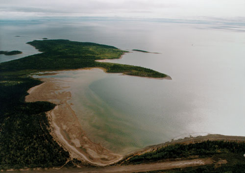
(55°22’ N 108°00’ W; Map sheet 74 N/8). Lake Athabasca is the largest lake in Saskatchewan with a surface area of 7,935 km2. It has the lowest elevation in the province at 213 m. Located in the northwest corner of the province and extending into Alberta, the rugged north shore comprises crystalline Archean rocks while the southern shore has extensive beaches and sand dunes derived from the Athabasca Basin. It is fed by the Peace, Athabasca and Fond du Lac rivers, and drains northward into Great Slave Lake via the Slave River. The name is of Cree origin; one possible meaning is “meeting place of many waters,” which aptly describes its location and emphasizes a characteristic that contributed to its prominent role in the fur trade. Samuel Hearne was the first European to see the lake in 1771. By 1788 a trade post was established at Fort Chipewyan (now in Alberta) and, somewhat later, to the east at Fond du Lac. From Lake Athabasca fur traders could access the Arctic, the Pacific and Hudson Bay. In the 20th century, the northern shores of the lake saw the development of Gold and uranium mining. The clean-up of former mine sites and the preservation of the sand-dune ecosystem along the south shore are contemporary issues of concern. Much of the latter ecosystem is now part of the Athabasca Sand Dunes Provincial Wilderness Park.
Marilyn Lewry
Print EntryHOME | BROWSE BY SUBJECT | ENTRY LIST (A-Z) | IMAGE INDEX | CONTRIBUTOR INDEX | ABOUT THE ENCYCLOPEDIA | SPONSORS TERMS OF USE | COPYRIGHT © 2006 CANADIAN PLAINS RESEARCH CENTER, UNIVERSITY OF REGINA | POWERED BY MERCURY CMS |
|||
| This web site was produced with financial assistance provided by Western Economic Diversification Canada and the Government of Saskatchewan. |
|||
| Ce site Web a été conçu grâce à l'aide financière de Diversification de l'économie de l'Ouest Canada et le gouvernement de la Saskatchewan. |
|||