Welcome to the Encyclopedia of Saskatchewan. For assistance in exploring this site, please click here.
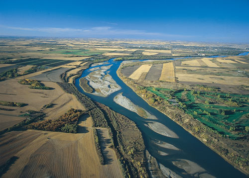
(53°15’N, 105°05’W; map sheet 73 H/3). Originating in the Rocky Mountains, the South Saskatchewan River is a combination of the Oldman, Bow and Red deer rivers and begins where the Oldman and Bow join, west of the city of Medicine Hat in Alberta. It flows in an easterly direction. After winding its way across the southern Alberta prairie grasslands, the Red Deer River adds its water a few kilometres east of the Alberta-Saskatchewan provincial boundary. The river continues flowing in an easterly direction into Lake Diefenbaker, where it changes its course to follow the northward slope of the land from Elbow to Gardiner Dam. The flows downstream of Lake Diefenbaker are controlled by Gardiner Dam, which has significantly changed the natural regime in the river, resulting in lower flows in the spring and early summer, and higher flows in the late fall and winter. After Gardiner Dam the river continues to flow in a northeasterly direction, past the city of Saskatoon, into the parkland region to join the North Saskatchewan River, east of Prince Albert, and become the Saskatchewan River.
The South Saskatchewan River watershed encompasses a total area of 172,900 km2, about 30% of the total watershed area being in Saskatchewan (51,800 km2). In a typical year more than 80% of the flow in the river is derived from the mountain and foothill region runoff. Peak flows typically occur in late May or June, in conjunction with mountain snowmelt runoff from the eastern slopes of the Rocky Mountains. The mean annual inflow into Saskatchewan is approximately 7.2 million dam3; the majority of this flow (93%) is passed through Lake Diefenbaker. The Swift Current Creek basin, which flows into Lake Diefenbaker just north of the city of Swift Current, is the only major watershed in Saskatchewan which contributes its waters into the South Saskatchewan River. (See also Hydrology, irrigation, Meewasin Valley Authority)
Bart Oegema
Print EntryHOME | BROWSE BY SUBJECT | ENTRY LIST (A-Z) | IMAGE INDEX | CONTRIBUTOR INDEX | ABOUT THE ENCYCLOPEDIA | SPONSORS TERMS OF USE | COPYRIGHT © 2006 CANADIAN PLAINS RESEARCH CENTER, UNIVERSITY OF REGINA | POWERED BY MERCURY CMS |
|||
| This web site was produced with financial assistance provided by Western Economic Diversification Canada and the Government of Saskatchewan. |
|||
| Ce site Web a été conçu grâce à l'aide financière de Diversification de l'économie de l'Ouest Canada et le gouvernement de la Saskatchewan. |
|||