Welcome to the Encyclopedia of Saskatchewan. For assistance in exploring this site, please click here.
Saskatoon, pop 196,811, is situated on the banks of the northward-flowing South Saskatchewan River, 235 km northwest of Regina, 348 km north of the US border, and 225 km east of the Alberta border. It serves as a regional centre for the northern prairies and for central and northern Saskatchewan.
Archaeological evidence shows that hunting tribes were here 6,000 years ago. Campsites, tipi rings, buffalo kills, and a medicine wheel uncovered at Wanuskewin Heritage Park, north of the city, indicate regular winter habitation by Native peoples. The first European settlers arrived in 1882, when John Lake of the Temperance Colonization Society came to examine the land granted to the colony by the Dominion government and to choose a site for the colony's administrative centre. This settlement on the east riverbank was called Saskatoon, after the Cree name for the berry bushes native to the area. Isolation, poor crops, and the North-West Resistance inhibited the community's growth after the first Temperance Colony settlers arrived in 1883.
Colony leaders lobbied for a rail connection; in 1887 the government granted the request, allowing a rail line to be built from the main Canadian Pacific Railway line, across the river at Saskatoon and towards Prince Albert. The railway located the station on the lower, flatter western bank to provide easier access to the water. The Temperance Society surveyed a new town site with the station as its centre, and in 1901, with a population of 113, the west-side settlement was incorporated as the village of Saskatoon while the original east-side settlement became Nutana. Saskatoon became a shipping centre exporting buffalo bones, cattle and grain.
The first burst of growth to the area came when the Saskatchewan Valley Land Company, a colonization company organized by midwestern capitalists, purchased over one million acres of land between Regina and Saskatoon. The settlement of land by the immigrants was vital to the community's growth. In 1903, over 1,500 Barr colonists (see Barr Colony) arrived from England and purchased goods from local merchants before migrating to the Lloydminster area.
Barr colonists who remained in the area established a third settlement, Riverdale, on the west side of the railway. In 1906, the villages of Saskatoon, Nutana and Riverdale (now Riversdale) amalgamated to form the city of Saskatoon, with a population of 4,500. The population soared over the next decade, new railway lines were constructed, and Saskatoon became the major distribution centre for central-southern Saskatchewan as well as a hub of western Canada's railway network. At the height of the boom in 1912, Saskatoon was Canada's fastest growing city, with an estimated population of 28,000. Quaker Oats, Robin Hood Flour, and the Massey Harris and Rumely farming implement companies were among the first industries to establish themselves in the city. As Saskatoon's economy was dependent on the wheat economy, growth declined during World War I, the global recessions of the 1920s, and the Depression of the 1930s. A lack of waterpower, isolation from large markets, and the dearth of investments prevented diversification of the economy through industrialization.
Significant development resumed after World War II. Saskatoon founded the expansion of its industrial base on the mining industry. In the 1940s five potash mines were in operation making Saskatoon the “Potash Capital of the World.” Increasing exploitation of oil and minerals in the western and northern parts of the province diversified the local economy. Chemical, textile, fibre optics, steel fabrication, food processing, engineering, and machinery industries established themselves, so that by the 1960s manufacturing had become increasingly important. Since the 1990s, major businesses have located in the city and there has been a significant development of high technology as many research firms located in the University's Innovation Place research park. As a result of its economic growth, the city has increased its population more than 300% between 1951 and the present.
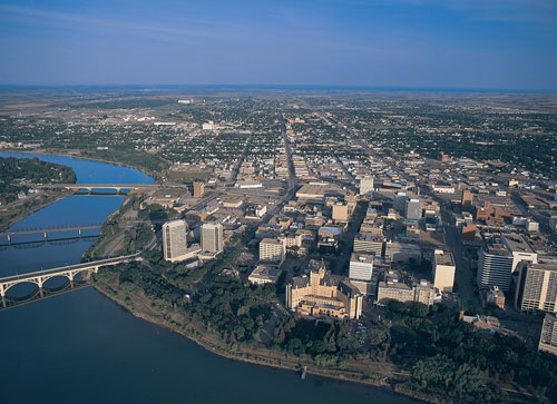
Saskatoon is located on glacial deposits within the belt of a large river, which gives the city a variable topography of rolling parkland and nearby oxbow lakes. The river is spanned by seven bridges, both rail and road, connecting Saskatoon, Riversdale and Nutana. A zoning plan for city development was established in 1929. During the two economic depressions the city acquired property through forfeiture of holdings, and in 1957 a “land bank” was developed through the purchase of available properties. The removal of the rail yards and their pedestrian overpass from the city centre in 1964-65 allowed for development of a downtown retail mall. Residential expansion is predominant in the northeastern sector, and country acreages in the Municipality of Corman Park are in increasing demand.
The initial settlers were from eastern Canada, the United Kingdom, and the United States. Then the city saw an increase in immigration from most parts of Europe, notably Ukraine and the Austro-Hungarian Empire, as well as from war brides and persecuted religious groups including Menonites, Hutterites and Doukhobors. Later decades saw an increase in immigration from India, Pakistan, Asia and Latin America, as well as a rapid growth in the Aboriginal population.
Saskatoon's public transport began with the operation of a ferry from 1884 until 1907, when the first bridge was built. In 1913 streetcars were introduced; they were eventually replaced by trolley buses, and then by buses. Canadian National transcontinental main line and a secondary line of Canadian Pacific Railway serve Saskatoon commercially, while VIA Rail maintains a minimal transcontinental passenger service. The present John G. Diefenbaker airport handles national and US flights. Saskatchewan Transportation Company provides provincial bus service and long distance service by Greyhound Bus Lines. Owing to its central location, Saskatoon is able to support over 90 local freight transport companies.
Saskatoon has seven radio stations, three TV stations, CBC studios, a daily newspaper, two community newspapers, and a weekly agricultural newspaper. Several outside telecommunications serve the area; however, SaskTel, the province's telephone company, is the primary provider of telecommunications services and Internet access to the public and other service providers.
The city charter, first introduced in 1906, specified a commission government requiring the city's officers to be the mayor and at least one appointed commissioner. In early elections, men voted in wards where they owned property; in 1920, however, female suffrage was introduced and the ward system was abolished. The ward system was reintroduced in 1973, and again abolished in 1988; after citizen protest, it was re-introduced yet again in 1991. City council now consists of the mayor and ten councillors, one for each ward and elected for three years. The city has two standing committees and several advisory committees, boards, and commissions with citizen representation. The Urban Municipality Act (1984) and the Planning and Development Act (1983) govern the relationship between municipal and provincial governments. In 1979 the Meewasin Valley Authority was established to conserve the riverbank and oversee development along the river corridor.
The University of Saskatchewan, its associated religious colleges, the SIAST-Kelsey Institute, the First Nations University of Canada, and the Saskatoon Public Library are the city's key educational institutions. Saskatoon is home to two professional theatre companies, Persephone and 25th Street, several festivals, and a symphony orchestra. Cultural and recreational facilities include the Western Development Museum, Ukrainian Museum of Canada, Mendel Art Gallery and Civic Conservatory, Saskatoon Zoo and Forestry Farm Park, Centennial Auditorium and Convention Centre, Credit Union Centre, Prairieland Park, and Wanuskewin Heritage Park. Saskatoon hosts events year-round: the Children's Festival, Jazz Festival, Folkfest, the Exhibition, the Riverfest with the River Roar and Taste of Saskatchewan, the Fringe Festival, the Canada Remembers Airshow, the Enchanted Forest, and Shakespeare on the Saskatchewan.
Daria Coneghan
Print EntryHOME | BROWSE BY SUBJECT | ENTRY LIST (A-Z) | IMAGE INDEX | CONTRIBUTOR INDEX | ABOUT THE ENCYCLOPEDIA | SPONSORS TERMS OF USE | COPYRIGHT © 2006 CANADIAN PLAINS RESEARCH CENTER, UNIVERSITY OF REGINA | POWERED BY MERCURY CMS |
|||
| This web site was produced with financial assistance provided by Western Economic Diversification Canada and the Government of Saskatchewan. |
|||
| Ce site Web a été conçu grâce à l'aide financière de Diversification de l'économie de l'Ouest Canada et le gouvernement de la Saskatchewan. |
|||