Welcome to the Encyclopedia of Saskatchewan. For assistance in exploring this site, please click here.
Hydrology is the study of water in and upon the Earth. Water movement in Saskatchewan is governed by the hydrologic cycle, as shown in Figure HYD-1 (facing page). The dominant components are precipitation, evapotranspiration, infiltration, and runoff. Precipitation includes rain, snow, sleet and hail. Evapotranspiration is a combination of evaporation from open water bodies and soil surfaces, and transpiration from plants. Infiltration is the movement of water downward through the soil profiles.
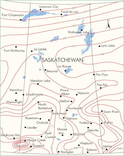
Annual precipitation and seasonal distribution vary considerably across the province. Figure HYD-2 displays the mean annual precipitation: it is less than 350 mm in southern parts of the province, while it exceeds 500 mm in the Cypress Hills or in northeastern Saskatchewan. Most areas receive at least 70% of the annual precipitation during the period April through October. Generally, less than 30% of the annual precipitation occurs during the winter period - except in the north, where the winter precipitation may be higher. The accumulation of snow is important to the hydrology of Saskatchewan, in that the melt rates and total accumulation cause higher flows during spring runoff.
Evapotranspiration is difficult to measure. Estimates have been calculated for gross evaporation from surface water bodies. In southern portions of the province, annual gross evaporation can exceed 1,000 mm, while in the north the gross evaporation may be in the order of 500 to 600 mm. Evaporation is affected by direct sunshine, wind, and air and water temperature. Estimates of soil surface evaporation and transpiration from plants are much less readily available. However, evapotranspiration is the largest component or output of the hydrologic cycle.
Infiltration is influenced by the coarseness of the soil, soil moisture, and pressure gradients. For example, sandy Soils have higher infiltration rates than soils with high clay content. Surficial gravel deposits have higher infiltration rates than sandy soils. If soil moisture levels are low, infiltration rates will generally be higher. Practically, infiltration rates are difficult to determine for specific locations without significant instrumentation. Typically, infiltration is in the same order of magnitude as surface runoff.
Runoff is the combination of overland flow, interstitial flow from the soil profile, and ground water discharge from below the water table. Runoff is monitored at approximately 300 locations throughout Saskatchewan at hydrometric stations run by the provincial and federal government. The median annual runoff expressed in millimeters is shown in Figure HYD-3. As can be seen, runoff is generally small compared to annual precipitation (usually much less than 50% of the annual precipitation for the prairie portion of the province). Generally runoff increases as one moves northward or eastward in the province.
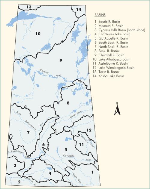
The major river basins in Saskatchewan are illustrated in Figure HYD-4. Starting in the southwest part of the province, the Missouri River basin drains southward into the Mississippi River and the Gulf of Mexico. Old Wives Lake basin is an internal drainage basin, with no outflow. The Souris, Qu'Appelle and Assiniboine rivers drain primarily eastward into the Red River/Lake Winnipeg basin, and then northward to Hudson Bay. Similarly, the Saskatchewan and Churchill River basins drain eastward and northward to Hudson Bay. The MacKenzie River basin, which includes all the drainage into Lake Athabasca, drains northward into the Arctic Ocean. (See also climate.)
Doug Johnson
Print EntryHOME | BROWSE BY SUBJECT | ENTRY LIST (A-Z) | IMAGE INDEX | CONTRIBUTOR INDEX | ABOUT THE ENCYCLOPEDIA | SPONSORS TERMS OF USE | COPYRIGHT © 2006 CANADIAN PLAINS RESEARCH CENTER, UNIVERSITY OF REGINA | POWERED BY MERCURY CMS |
|||
| This web site was produced with financial assistance provided by Western Economic Diversification Canada and the Government of Saskatchewan. |
|||
| Ce site Web a été conçu grâce à l'aide financière de Diversification de l'économie de l'Ouest Canada et le gouvernement de la Saskatchewan. |
|||