Welcome to the Encyclopedia of Saskatchewan. For assistance in exploring this site, please click here.
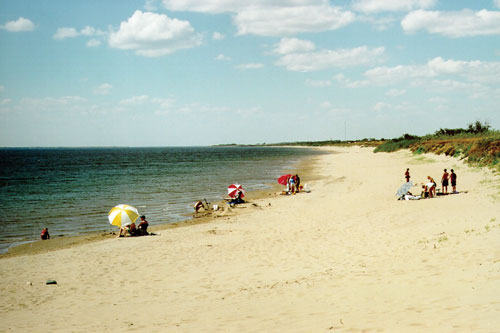
(50°43’N 107°30’W; Map sheet 72 J/11). Lake Diefenbaker is a T-shaped, artificial lake created along the valley of the South Saskatchewan River by the construction of the Gardiner Dam and Qu’Appelle River Dam, begun in 1959. It extends westward as far as Saskatchewan Landing. The reservoir, named after former prime minister John Diefenbaker, is part of the South Saskatchewan River Project. When full, it is 225 km long and has a maximum depth of approximately 58 metres, making this the largest lake in southern Saskatchewan. Because of the long stretches of open water and poorly consolidated shore materials, the banks of Lake Diefenbaker are vulnerable to erosion. Between 1968 and 1992, bank recession rates have commonly ranged up to three m/yr, with even higher rates in exposed areas. Unlike the creation of the more recent Rafferty and Alameda reservoirs, the formation of multi-purpose Diefenbaker Lake received widespread support in the 1950s. Recent economic analysis of the project concludes that it has made a significant economic and social contribution to the province, although Irrigation benefits have been less than predicted.
Marilyn Lewry
Print EntryHOME | BROWSE BY SUBJECT | ENTRY LIST (A-Z) | IMAGE INDEX | CONTRIBUTOR INDEX | ABOUT THE ENCYCLOPEDIA | SPONSORS TERMS OF USE | COPYRIGHT © 2006 CANADIAN PLAINS RESEARCH CENTER, UNIVERSITY OF REGINA | POWERED BY MERCURY CMS |
|||
| This web site was produced with financial assistance provided by Western Economic Diversification Canada and the Government of Saskatchewan. |
|||
| Ce site Web a été conçu grâce à l'aide financière de Diversification de l'économie de l'Ouest Canada et le gouvernement de la Saskatchewan. |
|||