Welcome to the Encyclopedia of Saskatchewan. For assistance in exploring this site, please click here.
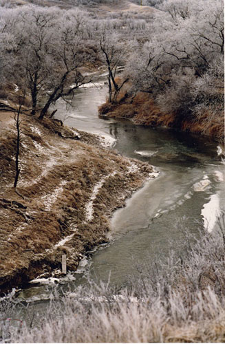
(50°29'N, 101°29'W; Map sheet 62 k/6). The east-flowing Qu'Appelle River, 430 km long and rising at the Qu'Appelle dam, 12 km southwest of Elbow, joins the Assiniboine River just east of the provincial boundary. Its tributaries include the Moose Jaw River and Wascana, Loon, Jumping Deer, Pheasant and Kaposvar creeks. The Qu'Appelle is a misfit stream, occupying a former glacial spillway once far larger than the present valley. Discharge of its tributaries is highly variable, greatest during spring run-off and dwindling to a trickle in late summer. Much of the flow in the Qu'Appelle itself is controlled. Water enters the river via the Qu'Appelle Valley dam, and about 100 kilometres downstream flows through Buffalo Pound Lake, a major source of domestic water for Regina and district, where a dam and control structure govern downstream discharge.
The word qu'appelle is French for “who calls” and is derived from its Cree name, kah-tep-was (“river that calls”). There are several versions of the origin of this name,but the most popular suggests it refers to a Cree legend of two ill-fated lovers. The Cree name occurs at Katepwa Beach, Katepwa Lake and Katepwa Point Provincial Park, all in the Qu'Appelle Valley north of Indian Head.
Marilyn Lewry
Print EntryHOME | BROWSE BY SUBJECT | ENTRY LIST (A-Z) | IMAGE INDEX | CONTRIBUTOR INDEX | ABOUT THE ENCYCLOPEDIA | SPONSORS TERMS OF USE | COPYRIGHT © 2006 CANADIAN PLAINS RESEARCH CENTER, UNIVERSITY OF REGINA | POWERED BY MERCURY CMS |
|||
| This web site was produced with financial assistance provided by Western Economic Diversification Canada and the Government of Saskatchewan. |
|||
| Ce site Web a été conçu grâce à l'aide financière de Diversification de l'économie de l'Ouest Canada et le gouvernement de la Saskatchewan. |
|||