Welcome to the Encyclopedia of Saskatchewan. For assistance in exploring this site, please click here.
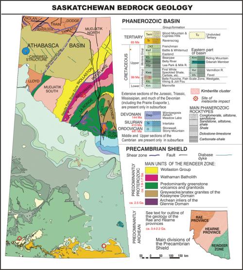
The geology of Saskatchewan is complex. The province is underlain throughout by crystalline Precambrian rocks of the stable North America Craton. In the north, these are exposed as part of the Canadian Shield. In the southern two-thirds of the province, the Precambrian basement is overlain by unmetamorphosed younger Phanerozoic sedimentary rocks. Thick ice sheets covered almost the entire region during the Pleistocene, leaving behind a variety of sculpted and deposit-strewn features. (See Figure GEO-1.)
Precambrian Shield. The Shield region is generally rugged and forested, with many bedrock exposures and lakes. The region has been divided geologically into a number of distinctive domains or terranes. In the past thirty years or so, detailed mapping and ever improving structural, geochemical and radiometric isotope techniques have been used to refine understanding of these terranes in terms of their age, origin, and assembly through plate tectonic and other processes.
The oldest rocks found so far, dated at about 3.4 Ga. (billion years), occur north of Lake Athabasca. The Hearne and Rae geological provinces comprise rocks of late Archean/Early Proterozoic age, mostly in the range 2.7 to 2.2 Ga. Many of these are of high metamorphic grade (granulite through amphibolite facies), produced in deeply buried crust at the roots of mountain ranges similar to the Alpine ranges of today, and now exhumed. The Wollaston belt to the southeast comprises mainly foreland basin sediments overlying Archean basement remobilized in Proterozoic times. The Reindeer Zone in the southeast is a collage of juvenile Proterozoic greenstone volcanics, greywacke and granitic rocks dated approximately 1.9 to 1.75 Ga. These greenstone belts are associated with the major base metal mine at Flin Flon, as well as gold deposits. The domains are generally bounded by major shear zones, such as the Needle Falls shear zone and the Snowbird line, which accommodated extensive translational movement during assembly of the terranes. Unmetamorphosed sandstones and other sediments of the Athabasca basin, which overlie much of the north-central part of the Shield, have been dated at about 1.7 Ga. Saskatchewan’s world-renowned uranium deposits are related to the weathered regolithic interface between the Athabasca Group and the underlying basement.
Subsurface Precambrian of the South. The Precambrian basement surface declines gradually from the Shield edge towards the south, taking a deeper plunge from about Regina southeastwards, to a maximum depth of about 3,300 m. Regional geophysical airborne surveys, deep seismic probing, and samples from oil wells have enabled mapping of domains, similar to those of the Shield area, in Precambrian basement rocks underlying the Phanerozoic rocks to the south.
Phanerozoic Geology. The wedge of Phanerozoic sediments overlying the Precambrian basement are part of the Western Canada Sedimentary Basin. Although rarely exposed, these sediments have been studied extensively at subsurface from extensive oil well drillings by the oil industry. The lower sedimentary sequences formed during an initial Cambrian to Middle Jurassic passive-continental margin phase, and comprise basal clastics, platform carbonates and evaporites, including the major potash deposits of the Prairie Evaporite. These were succeeded by a Middle Jurassic to Eocene convergent-margin phase that produced a foreland basin with thick accumulations of largely clastic sediment derived from the emerging Cordilleran Mountain Belt to the west. Tertiary sands and gravels, along with extensive kaolin deposits, are exposed mainly in the US border region.
The basin is affected by episodic downwarping of the intracratonic Williston Basin in the south, block tectonic movements due to reactivation of basement structures, and eustatic sea-level changes. These factors, together with post-depositional folding and evaporate dissolution effects, have largely governed the distribution of the important resources of oil, natural gas, coal, and potash.
Other features. The largest known cluster worldwide of kimberlite volcanoes, with intact fallback deposits, a potential major source of Diamonds, occurs mainly in the Fort à la Corne area, by the Saskatchewan River. These were extruded in shallow marginal Cretaceous seas about 100 million years ago. Major meteorite impact structures (astroblemes) include the Carswell, Deep Bay and Gow Lake in the Shield, and the Viewfield, Elbow and Maple Creek structures in the south.
Glacial Geology. At least eight periods of glacial advance and retreat are recorded in Saskatchewan during the Middle to Late Pleistocene, affecting all but small areas of the Cypress Hills and Wood Mountain which stood above the ice sheets. Whereas the Shield is primarily a region of glacial erosion and scour, the Phanerozoic outcrop is largely a region of glacial deposition, with till sequences as much as 100 m or more thick in many places. Strong movements of the ice sheets produced thrust-stacked sequences of the glacial deposits and bedrock in some places.
R. Macdonald
Print EntryHOME | BROWSE BY SUBJECT | ENTRY LIST (A-Z) | IMAGE INDEX | CONTRIBUTOR INDEX | ABOUT THE ENCYCLOPEDIA | SPONSORS TERMS OF USE | COPYRIGHT © 2006 CANADIAN PLAINS RESEARCH CENTER, UNIVERSITY OF REGINA | POWERED BY MERCURY CMS |
|||
| This web site was produced with financial assistance provided by Western Economic Diversification Canada and the Government of Saskatchewan. |
|||
| Ce site Web a été conçu grâce à l'aide financière de Diversification de l'économie de l'Ouest Canada et le gouvernement de la Saskatchewan. |
|||