Welcome to the Encyclopedia of Saskatchewan. For assistance in exploring this site, please click here.
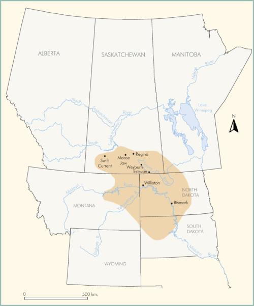
The Williston Basin is a sedimentary basin centred near Williston, North Dakota, which underlies some 250,000 km2 in North Dakota, Manitoba, Saskatchewan, Montana and South Dakota (see Figure WB-1). This major geological feature is essentially a near-circular sub-basin within the Western Interior Basin of the United States and the adjoining Western Canada Sedimentary Basin. The thickness of sedimentary strata at the centre of the basin is about 5,000 m. The sedimentary succession thins outward, and is just over 3,300 m on the International Boundary south of Regina. The outer limit of the basin is commonly set where the basin fill thins to 2,400 m. The oldest strata in the Williston Basin were laid down in Cambrian time approximately 550 million years ago. These beds rest upon more ancient Precambrian crystalline rocks, the “Basement” of petroleum geologists. The youngest beds are late Tertiary in age, deposited about five million years ago. Important reserves of petroleum have been developed in the Williston Basin; many of the producing oil pools are located in southeastern Saskatchewan. Lignite coal in the near-surface Tertiary rocks is mined in Saskatchewan and North Dakota; deeply buried potash beds may be exploited in the future.
Laurence Vigrass
Print EntryHOME | BROWSE BY SUBJECT | ENTRY LIST (A-Z) | IMAGE INDEX | CONTRIBUTOR INDEX | ABOUT THE ENCYCLOPEDIA | SPONSORS TERMS OF USE | COPYRIGHT © 2006 CANADIAN PLAINS RESEARCH CENTER, UNIVERSITY OF REGINA | POWERED BY MERCURY CMS |
|||
| This web site was produced with financial assistance provided by Western Economic Diversification Canada and the Government of Saskatchewan. |
|||
| Ce site Web a été conçu grâce à l'aide financière de Diversification de l'économie de l'Ouest Canada et le gouvernement de la Saskatchewan. |
|||