Welcome to the Encyclopedia of Saskatchewan. For assistance in exploring this site, please click here.
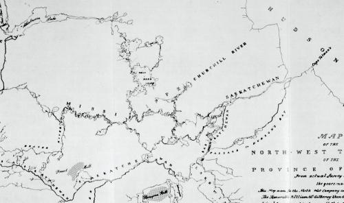
The history of the exploration of Saskatchewan has not been well documented. The contribution of Aboriginal people is largely unacknowledged, although all explorers depended upon their knowledge, skills and experience. By 1810, David Thompson and Peter Fidler had compiled maps of nearly all the major waterways; nevertheless, the mapping of Saskatchewan was not completed until the mid-1940s.
European traders arrived on the western shore of Hudson Bay in 1682, but for over 70 years the only description of the northern plains was Henry Kelsey's brief nine-week journal of 1691. The La Vérendryes reached the mouth of the Saskatchewan River in 1741, and their immediate successors established posts further upriver and on the Red deer River, but they did not describe the Saskatchewan landscape. Between 1754 and 1774, the Hudson's Bay Company (HBC) at York Factory sent men inland to winter with Cree people on the northern plains. Journals from four of these men survive; unfortunately, they seldom identified specific geographical features, and their routes are difficult to retrace.
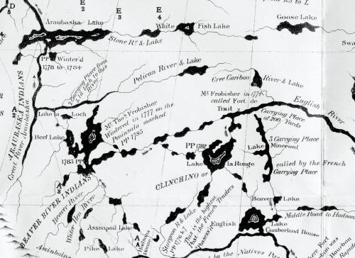
The first crude maps of the interior were drawn by Peter Pond in the 1780s. In 1790, while at Cumberland House, David Thompson and Peter Fidler were taught surveying skills by Philip Turnor. These two men mapped all the main provincial waterways except for the region west of Reindeer Lake. Their information was used in the famous Arrowsmith maps of North America published between 1791 and 1857. Most of their records remain unpublished, including Fidler's copies of the few surviving Aboriginal maps of Saskatchewan.
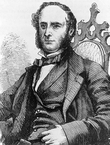
In 1801, Alexander Mackenzie published a best-selling account of his journeys to the Arctic and Pacific Oceans, including a detailed description of the Churchill River. Daniel Harmon, Gabriel Franchère and other traders then began publishing their experiences. More importantly, in 1819 the British government sponsored John Franklin's four-year expedition to the Arctic. Franklin's account included several chapters describing the Cumberland and Fort Carlton areas. Later travelers into the far northwest, including George Back, Richard King and John Richardson, also published their accounts but contributed little that was new. The increased publicity of the West and the development of the Carlton Trail attracted adventurers such as the Earl of Southesk, Viscount Milton, W.B. Cheadle, George Grant, William Butler, and Thomas McMicking. However, their accounts all lack detailed geographical observations.
By the 1850s, interest developed in the resource and settlement potential of the northern plains. In 1857-60, the British government sent John Palliser (see Palliser and Hind Expeditions) to explore the area between the Assiniboine River and the Rocky Mountains. Skilled expedition members collected a wide range of information while Palliser's large, detailed map remained the basis for later maps for many years. In 1858, the Canadian government sent Henry Youle Hind and Simon J. Dawson to explore the area between Lake Winnipeg and the South Saskatchewan River. Hind lacked personnel, and his account is somewhat superficial. The last major mapping expedition across the south was the British-American Boundary Commission of 1872- 74, which resulted in a detailed geological report by G.M. Dawson. In 1872, John Macoun began evaluating agricultural potential with a series of expeditions across central Saskatchewan which were initially part of the railway and telegraph surveys carried out under Sandford Fleming. Then, between 1877 and the 1920s the Dominion Land Survey carried out a massive program, mapping over 3,000 individual townships across the southern half of the province. This resulted in the series of “sectional maps” which were the first accurate maps of the settled portion of Saskatchewan.
By the late 1800s, the Geological Survey of Canada began focussing on the potential for mineral resources. J.B. Tyrrell, the last of the great inland explorers, mapped the country west of Reindeer Lake in 1892, and later crossed into the Barrens. Finally, between 1907 and 1910 William McInnes mapped the region between the Churchill and Carrot Rivers, while Frank Crean explored the forested area to the west. These ended the large regional surveys, although geologists still continue today to map and describe smaller units of land. The first aerial photography surveys began in 1924, eliminating the need for ground mapping. They resulted in the present topographic maps at a scale of 1.25 miles/inch. Satellite coverage became generally available after 1972. Today, satellites offer a wide range of imagery, which can be updated on a daily basis, providing much environmental data for scientific analysis. To this day, however, the only descriptions of many landscapes throughout the province are those made by Thompson and Fidler, 200 years ago.
Dale Russell
Print EntryHOME | BROWSE BY SUBJECT | ENTRY LIST (A-Z) | IMAGE INDEX | CONTRIBUTOR INDEX | ABOUT THE ENCYCLOPEDIA | SPONSORS TERMS OF USE | COPYRIGHT © 2006 CANADIAN PLAINS RESEARCH CENTER, UNIVERSITY OF REGINA | POWERED BY MERCURY CMS |
|||
| This web site was produced with financial assistance provided by Western Economic Diversification Canada and the Government of Saskatchewan. |
|||
| Ce site Web a été conçu grâce à l'aide financière de Diversification de l'économie de l'Ouest Canada et le gouvernement de la Saskatchewan. |
|||