Welcome to the Encyclopedia of Saskatchewan. For assistance in exploring this site, please click here.
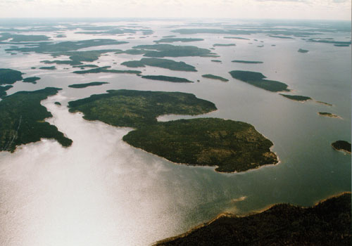
(57°15’N, 102°15’W; Map sheet 64 E/1). Most of Reindeer Lake is located in northeastern Saskatchewan, although part of its eastern shore and northeastern tip are in Manitoba. Reindeer is Saskatchewan’s second largest lake, covering 6,650 km2 with a maximum length of 233 km. It is elevated at 337 m, and drains southward into the Churchill River. Reindeer Lake has a highly indented shoreline with numerous islands. Located near its southern end is the almost circular Deep Bay, covering an astrobleme that probably formed about 100 million years ago. Although a number of explorers, including David Thompson, traversed Reindeer Lake, it was not heavily used during the fur trade era. Several trading posts were established in the 1790s and early 1800s, but none lasted more than a year or so.
Southend Indian reserve (2001 population: 696), at the southern tip of the lake, lies at the terminus of Highway 102. This provides the lake’s only Saskatchewan road access, although the tiny community of Kinoosao, near the Manitoba border, is served by Highway 394 from Lynn Lake. Most employment is related to the provision of services to local communities, but Reindeer Lake also supports a tourist industry; there are several fishing camps on the lake.
Marilyn Lewry
Print EntryHOME | BROWSE BY SUBJECT | ENTRY LIST (A-Z) | IMAGE INDEX | CONTRIBUTOR INDEX | ABOUT THE ENCYCLOPEDIA | SPONSORS TERMS OF USE | COPYRIGHT © 2006 CANADIAN PLAINS RESEARCH CENTER, UNIVERSITY OF REGINA | POWERED BY MERCURY CMS |
|||
| This web site was produced with financial assistance provided by Western Economic Diversification Canada and the Government of Saskatchewan. |
|||
| Ce site Web a été conçu grâce à l'aide financière de Diversification de l'économie de l'Ouest Canada et le gouvernement de la Saskatchewan. |
|||