Welcome to the Encyclopedia of Saskatchewan. For assistance in exploring this site, please click here.
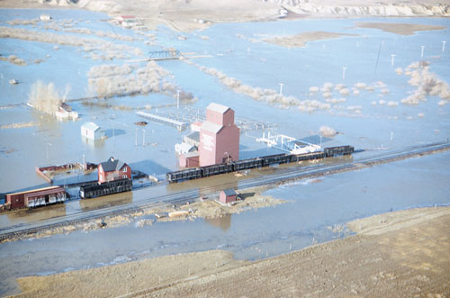
There have been numerous well-documented floods in Saskatchewan since Euro-Canadian settlement began. They have usually been caused by large snowmelt spring runoffs or large summer rainfall events. In rare cases, flooding may result from a significant ice jam or from several consecutive high-flow years. Illustrated (below) is the 1952 flood in Eastend, caused by a rapid melt of a large snow pack. Severe flooding also occurred at Fishing Lake near Wadena, caused by successive high-runoff years in the 1990s. Fishing Lake lacks an effective outlet channel, which restricts outflow from the lake. Several years with high spring runoff and summer rainfall caused Fishing Lake to rise to flood stage and remain so for a prolonged period, causing significant damage.
From the 1970s through the 1990s, the governments of Saskatchewan and Canada entered into an agreement and program aimed at reducing flood damage. Twenty-six communities participated in the Flood Damage Reduction Program (FDRP). Design floods were calculated and flood plains were mapped; communities were encouraged to develop bylaws restricting development on flood plains. In at least one community, dykes were constructed to protect existing properties and homes; in other communities, funds were set aside to purchase flood- prone properties in the flood plains. Saskatoon, Estevan and Oxbow are located downstream from major multipurpose dams which are used to reduce flood impacts.
Saskatchewan Watershed Authority also runs the River Forecast Centre (RFC), which monitors stream flows and water levels throughout the province and forecasts flows and water levels during critical periods. Information is gathered from a stream flow gauging network of approximately 300 hydrometric stations, owned and operated by the Authority or by Environment Canada; meteorological information is obtained from Environment Canada. Flood warnings and flow forecasts are important components of flood operations.
Doug Johnson
Print EntryHOME | BROWSE BY SUBJECT | ENTRY LIST (A-Z) | IMAGE INDEX | CONTRIBUTOR INDEX | ABOUT THE ENCYCLOPEDIA | SPONSORS TERMS OF USE | COPYRIGHT © 2006 CANADIAN PLAINS RESEARCH CENTER, UNIVERSITY OF REGINA | POWERED BY MERCURY CMS |
|||
| This web site was produced with financial assistance provided by Western Economic Diversification Canada and the Government of Saskatchewan. |
|||
| Ce site Web a été conçu grâce à l'aide financière de Diversification de l'économie de l'Ouest Canada et le gouvernement de la Saskatchewan. |
|||