Welcome to the Encyclopedia of Saskatchewan. For assistance in exploring this site, please click here.
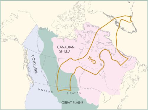
The Trans-Hudson Orogen (THO) (see Figure THO-1) is the highly eroded remains of an ancient mountain belt in northern Canada, which originally (about 1.8 billion years ago) would have rivalled the Himalayas in grandeur. It is part of the Precambrian Canadian Shield, and its geological history marks an important stage in the forging of the North American continent. The THO extends from its main outcropping region in northern Saskatchewan and Manitoba, northeasterly to underlie the Phanerozoic rocks of the Hudson Bay Lowlands, under Hudson Bay, across Baffin Island, and possibly across Greenland under the glaciers, with a branch into northeastern Quebec and Labrador. To the south, it has been traced in subsurface under the Phanerozoic strata of the Great Plains into northern Montana and the Dakotas.
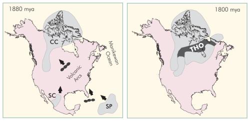
Like all orogens (tectonic mountain belts), regardless of their time of formation, the THO formed as a result of the collision of tectonic plates, which in this case (Figure THO-2) were three Archean microcontinents: the Superior Province (SP on Figure THO-2), the Churchill Craton (CC on Figure THO-2), and the now mostly buried Sask Craton (SC on Figure THO-2). These were once scattered several thousand kilometres apart in the early Proterozoic Manikewan Ocean.
The exact borders of these microcontinents are speculative because of their considerable modification (deformation) during collision. The present-day outline of North America is shown on Figure THO-2 for location purposes only.
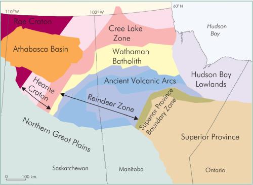
The Manikewan Ocean contained at least two long chains, or arcs, of largely submarine volcanoes (Figure THO-2), the result of ancient plate-subduction-related volcanism, not unlike several similar chains of volcanic islands in the modern-day south Pacific. Erosion of these volcanoes, along with erosion of the various microcontinents, produced thick piles of sedimentary rock which, along with the volcanic rock, make up much of the rock material in the present THO. In Saskatchewan alone, irregular patchwork piles of metamorphosed ancient volcanic arc (AVA, see Figure THO-3) rock, locally greater than 10 km thick, underlie more than 10,000 square km of terrain. Volcanoes were active mainly between about 1.9 and 1.8 billion years ago, although we can no longer identify individual volcanoes because of deformation and erosion.
All orogens, including the THO, are identified by the folding and faulting that has affected the rocks, and by the metamorphism that has transformed various rocks into their metamorphic equivalents such as schists and gneisses. This plate tectonic closure of the Manikewan Ocean not only produced the THO, but also formed the proto-continent or core of North America (Figure THO-2).
Also like all orogens, the THO contains hundreds of huge bodies of intruded granitoid rocks, such as the gigantic Wathaman batholith (WB, see Figure THO-3) in Saskatchewan and Manitoba. The WB was injected about 1.855 billion years ago into older, mainly marine, volcanic and sedimentary rocks, most of which had been deposited between about 1.9 and 1.855 billion years ago. Although most of these rocks were deposited on the Manikewan seabed, underlain by oceanic crust (Reindeer Zone, RZ on Figure THO-3), some were deposited on ancient continental shelves formed by “under-the-sea” extensions of older continental crust: the Hearne Craton in the west (part of the CC) is overlapped by the Cree Lake Zone (CLZ on Figure THO-3); and the Superior Craton in the southeast is overlapped by the Superior Province Boundary Zone (SPBZ, see Figure THO-3). The Sask Craton (SC) has been buried as rocks of the THO were thrust over it during collision.
M. Stauffer
Print EntryHOME | BROWSE BY SUBJECT | ENTRY LIST (A-Z) | IMAGE INDEX | CONTRIBUTOR INDEX | ABOUT THE ENCYCLOPEDIA | SPONSORS TERMS OF USE | COPYRIGHT © 2006 CANADIAN PLAINS RESEARCH CENTER, UNIVERSITY OF REGINA | POWERED BY MERCURY CMS |
|||
| This web site was produced with financial assistance provided by Western Economic Diversification Canada and the Government of Saskatchewan. |
|||
| Ce site Web a été conçu grâce à l'aide financière de Diversification de l'économie de l'Ouest Canada et le gouvernement de la Saskatchewan. |
|||