Welcome to the Encyclopedia of Saskatchewan. For assistance in exploring this site, please click here.
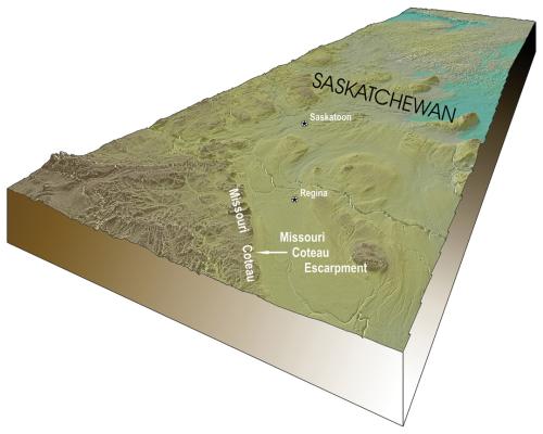
The Missouri Coteau, hereafter called “the Coteau,” is a narrow band of prairie upland that stretches from southern Saskatchewan to South Dakota. In Saskatchewan, the Coteau is a hummocky, pothole-dotted grassland underlain by thick glacial sediments. Approximately 15 to 40 km in width, it is bordered on the east by a prominent linear escarpment, and on the west by undulating topography and thinner glacial sediments. Throughout history, vistas of the Coteau's shimmering blue eastern slope have caught the attention of Aboriginal hunters, cattle ranchers and sightseers. Located in Saskatchewan's driest ecosystem, the Coteau is home to a diverse community of well-adapted wildlife and vegetation. Each spring, snowmelt fills innumerable ponds that become home and habitat to great numbers of incoming ducks, shore and wading birds, whose April and May arrivals are followed by flocks of grassland songbirds.
The origin of the Coteau lies deep below its grassy surface. Geophysical studies reveal linear structures in 2-billion-year-old crystalline rocks that underlie the Coteau at depths of 3 km. Above these ancient basement rocks, steep faults associated with basement structures penetrate hundreds of metres of sedimentary rock that began forming 550 million years ago - long and linear faults leaving their stamp on the Coteau's origin, location and appearance. During the Mesozoic era, the earth beneath the Coteau heaved and subsided in response to deep crustal forces. Nearly a kilometre of alternating up and down movement occurred during this 200-million-year period. The most recent upward crustal motions, beginning approximately 30 million years ago, created a regional highland that extends from the Coteau to the Cypress Hills in southwest Saskatchewan. It was during this time that surface erosion formed the Missouri Coteau escarpment, which gradually eroded westward to its present position.
The Coteau we see today has been shaped by several glaciations. During the last glacial maximum, beginning about 25,000 years ago, the advancing ice eroded clay-rich sediment from older glacial deposits and bedrock. Flowing southward, the ice front encountered the pre-glacial Missouri Coteau escarpment, which deflected ice flow toward the southeast. At the same time, the glacier's momentum thrust huge slabs of sediment-laden ice onto high ground south of the escarpment. As glacier ice melted from the highlands, more than 60 m of sediments were deposited as hills and ridges, typifying the Coteau topography. The ensuing postglacial climate dictated the type of soil, vegetation, water resources, wildlife and land use we see today.
Lynden Penner
Print EntryHOME | BROWSE BY SUBJECT | ENTRY LIST (A-Z) | IMAGE INDEX | CONTRIBUTOR INDEX | ABOUT THE ENCYCLOPEDIA | SPONSORS TERMS OF USE | COPYRIGHT © 2006 CANADIAN PLAINS RESEARCH CENTER, UNIVERSITY OF REGINA | POWERED BY MERCURY CMS |
|||
| This web site was produced with financial assistance provided by Western Economic Diversification Canada and the Government of Saskatchewan. |
|||
| Ce site Web a été conçu grâce à l'aide financière de Diversification de l'économie de l'Ouest Canada et le gouvernement de la Saskatchewan. |
|||