Welcome to the Encyclopedia of Saskatchewan. For assistance in exploring this site, please click here.
The Dominion Land Survey System laid out nearly uniform land parcels that can be precisely described and located in the settled areas of the four western provinces.
This system was designed to describe essentially agricultural land areas in an understandable and detailed manner down to ten acres (4 ha) in size. Cities, First Nations reserves, federal parks, the older river lots, and lands that were Hudson’s Bay Company posts were excluded from the survey. The system was based on a model used in the mid-western United States. Both plans used a one square mile land unit. The Canadian system was modified from the US system to exclude road allowances from the land to be used for agriculture. In Canada there were five variations in the system, largely related to roadway accommodation and how the convergence of the lines of longitude was handled.
Difficulties in mountainous terrain and the overlapping of a flat grid system meant that only small portions of British Columbia were surveyed under the system. Almost all the settled areas of Manitoba, Saskatchewan, and Alberta were, however, surveyed and remain under the original land description system, except for the local areas already mentioned as being outside this system. When urban areas were being created, a new plan was laid over the original survey; and where this occurs, the city or town type of survey using blocks and lots prevails.
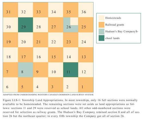
The basic system was a grid. The major grid boundaries comprised of township lines paralleling the lines of latitude, and of a system of range lines largely paralleling the lines of longitude. Within these east-west and north-south grid lines, which occur about every six miles (six miles plus road allowances) are divisions creating blocks of land called sections, as near as possible to one mile by one mile square, i.e., 640 acres or close to 259 ha. Figure LLS-1 and its legend show how the sections are numbered as well as the original land appropriations.
These sections are subdivided into quarters, and on occasion the sections may have been subdivided into legal subdivisions and quarters of legal subdivisions. The quarters contained more or less 160 acres (about 65 ha), and the legal subdivisions were sixteen per section or forty acres (16 ha) each. The townships, ranges, sections and legal subdivisions are numbered, while the quarter sections and quarters of legal subdivisions are identified by their compass location, i.e., the southwest, southeast, northwest and northeast quarters within a section. Townships are numbered consecutively from the United States border northward, and ranges are numbered westward from each meridian. There are range lines at the prime meridian just west of Winnipeg, and thereafter at each meridian. The second range line is at 102° west longitude, and then every four degrees of longitude to the west. This allows identification of land parcels when the legal land description is known and understood.
The legal description of land follows a set sequence of quarter section, township, range, and meridian: the designation NW27-9-25W2, for instance, means the northwest quarter of section 27 in township 9 range 25 west of the second meridian, i.e., near Assiniboia. In the original survey marker pegs were set out on the quarter sections, and these survey stakes contained the land identification cut into them in Roman numerals.
The system was implemented on July 10, 1871, in Manitoba and continues to be used in more isolated areas. The survey was carried out in advance of the western movement of settlement. For instance, the Saskatchewan area survey began in 1877, Alberta in 1881, and a small area near New Westminster, British Columbia in 1874.
R.B. McKercher
Print EntryHOME | BROWSE BY SUBJECT | ENTRY LIST (A-Z) | IMAGE INDEX | CONTRIBUTOR INDEX | ABOUT THE ENCYCLOPEDIA | SPONSORS TERMS OF USE | COPYRIGHT © 2006 CANADIAN PLAINS RESEARCH CENTER, UNIVERSITY OF REGINA | POWERED BY MERCURY CMS |
|||
| This web site was produced with financial assistance provided by Western Economic Diversification Canada and the Government of Saskatchewan. |
|||
| Ce site Web a été conçu grâce à l'aide financière de Diversification de l'économie de l'Ouest Canada et le gouvernement de la Saskatchewan. |
|||