Welcome to the Encyclopedia of Saskatchewan. For assistance in exploring this site, please click here.
The Saskatchewan Act, passed by the Canadian Parliament on September 1, 1905, created the contemporary boundaries of Saskatchewan. The international boundary along the 49th Parallel was demarcated first. Internal boundaries—along the 60th parallel in the north; 110° W in the west; and between 60° N, 102° W and 49° N, 101°30’ W in the east—were designated between 1881 and 1905.
The 49th parallel was first established as the international boundary by the Treaty of Utrecht in 1713, reinforced by the Treaty of Paris in 1783 and ultimately designated by British-American Convention in 1818. The boundary was initially surveyed between 1872 and 1875.
The Dominion Lands Survey was established in 1868 by a federal Order-in-Council, although events in Red River in 1869 and 1870 prevented its widespread application until 1871. The Dominion Lands Survey enabled the division of western lands among the Hudson’s Bay Company (HBC), the Canadian Pacific Railway (CPR) and homesteaders, and set aside two sections in each township for the future of local Education. Except in the extreme south, most prairie lands between 50° and 55° north, were surveyed by the end of 1883.
With Canada’s purchase of Rupert’s Land (the former HBC territory; see Rupert’s Land Purchase) and the North-Western Territory from the British in 1870, the region came under the political, social and economic aegis of the Dominion of Canada. Ottawa exerted complete control over the shape, dissemination and regulation of land.
Before the creation of the province of Manitoba, the most important regions of the west had been the HBC’s fur-trade districts. As population and administrative demands grew, Ottawa and the territorial governments deemed more internal divisions necessary. The North-West was divided into different units, for different purposes. With the creation of the “Postage Stamp” province of Manitoba in 1870, the internal organization of the North-Western Territory began to change, beginning with its renaming to North-West Territories. In 1878 the administrative centre of the territory was moved from Fort Livingstone to Battleford. Each centre had a land registration office and two more were opened in Westburne and Dufferin. That same year four judicial districts were created. In 1884, these were divided into seven judicial districts, four of which (Regina, Medicine Hat, Calgary and Fort Macleod) were located in the south where the North-West’s population was growing rapidly.
By 1880, population numbers warranted the creation of three electoral districts to meet the Canadian standard for representation in the Territorial Assembly. However, in 1881 the province of Manitoba was enlarged by Ottawa (Dominion Act, July 1, 1881) to include the electoral districts of Wallace and Moosomin, North-West Territories. This Act established the ultimate eastern boundary of the province “on the centre of the road allowance between the twenty-ninth and thirtieth ranges west of the Principle Meridian.”
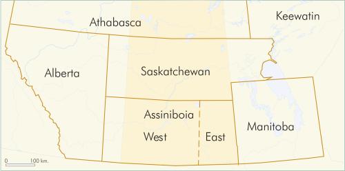
In May 1882, four “provisional districts” were created (Figure BSK-1 on facing page). Later, in 1886, Assiniboia was divided into eastern and western districts. These “provisional” districts were not legally defined Canadian provinces, nor were they legal territories, but before 1905 they were the North-West’s clearest internal boundaries with the potential to become provinces.
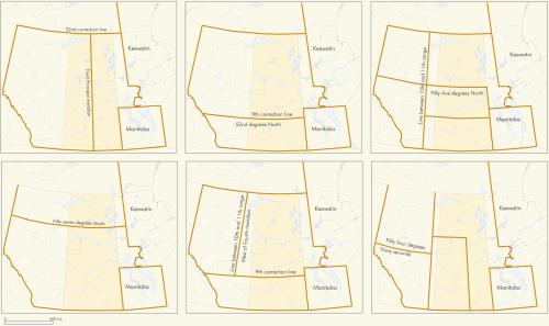
As early as 1872, J.S. Dennis, the Surveyor General of Dominion Lands, had advanced proposals to divide the west into provinces. Plans were reiterated in 1882 and thereafter regularly put forward to the Ottawa government. Before 1905 scenarios for four, three, two and one province had been proposed (Figure BSK-2). The Canadian government only considered those that would result in one or two provinces, with the latter being preferred.
The ruling Liberals (and most vociferously Prime Minister Laurier) cited two reasons for dividing the North-West Territories. The first involved the relative sizes of then contemporary provinces. To Laurier, it was obvious that a North-West Territories of 1,791,1682 km was much too large compared to other provinces. Second, Laurier argued there was a certain economic raison d’être for separateness: Alberta was Ranching country; Saskatchewan was farming. Provinces would thereby simply be based on land-use patterns and similarities in lifestyles. The actions of Laurier’s government to create two provinces, separated along the fourth initial meridian, were consistent with those of Sir John A. Macdonald, who had often emphasized the paramount power of the federal government. However, those boundaries, created on paper in 1905 when Saskatchewan became a province, were not surveyed in their entirety until the end of the 1960s.
Ben Moffat
Print EntryHOME | BROWSE BY SUBJECT | ENTRY LIST (A-Z) | IMAGE INDEX | CONTRIBUTOR INDEX | ABOUT THE ENCYCLOPEDIA | SPONSORS TERMS OF USE | COPYRIGHT © 2006 CANADIAN PLAINS RESEARCH CENTER, UNIVERSITY OF REGINA | POWERED BY MERCURY CMS |
|||
| This web site was produced with financial assistance provided by Western Economic Diversification Canada and the Government of Saskatchewan. |
|||
| Ce site Web a été conçu grâce à l'aide financière de Diversification de l'économie de l'Ouest Canada et le gouvernement de la Saskatchewan. |
|||