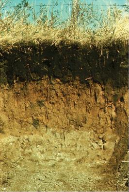
Soils are natural bodies formed by the cumulative effects of climate, vegetation, geological material, topography, and drainage. These effects are expressed by the development of a series of layers or “horizons” extending from the surface downward into the unaltered geologic or parent material (see Figure S-1, inset). This whole succession of horizons is referred to as the “soil profile.” In describing soils, three main horizons are recognized from the surface downwards and are indicated by the letters A, B and C respectively. The A horizon, the uppermost layer, usually contains most of the organic matter (the source of most plant nutrients) and is thus darker in colour than the rest of the profile; soil in the A horizon typically constitutes the plough layer in cultivated soils. The B horizon, typically brownish in colour, is often slightly finer in texture (more clayey) than the A horizon. The C horizon represents the largely unaltered geologic deposit and is commonly referred to as the soil parent material, or the material from which the soil was developed; in most Saskatchewan soils the C horizon occurs between 50 and 100 centimetres. Most Saskatchewan soils have developed in glacial deposits, laid down either by ice or by water from the melting ice. Glacial till, the material carried and deposited by ice, is the most common type of parent material; soils developed in glacial till are commonly loamy in texture. Sandy and gravelly soils are typically developed on glaciofluvial deposits laid down by moving meltwater, while silty and clayey soils are found mainly in former glacial lakes.
Over broad regions and long periods of time, differences in climate and in the related natural vegetation have a pronounced effect on soil formation. Thus, in Saskatchewan over the past 10,000 years, forces of climate acting upon the landscape and geologic materials left by the retreating glaciers have created broad distinctive zones of vegetation and soil; in fact, in no other part of the country are these zonal relationships so clearly displayed (see Figure S-2, left). In the southwest, a dry climate yielded short-grass prairie vegetation and Brown or Dark Brown soils having a thin surface layer low in organic matter. These dry conditions give way northward and eastward to parkland vegetation, characterized by a mix of aspen groves and fescue grasslands reflecting slightly cooler and moister conditions compared to the prairie region. There the soils have high levels of organic matter at the surface, and are thus dark or black in colour. Further north, under an even cooler and more humid climate, forest vegetation prevails and the soils have little or no organic matter, which gives them a distinctive grey appearance. In Saskatchewan, soils are classified or named according to the Canadian System of Soil Classification, which is based on a concept first developed by early (1870s) Russian soil scientists: soil is a natural body with “horizons” and “profiles” that reflect influences of climate and vegetation acting on the surficial material. Thus, classification of Saskatchewan soils is based mainly on the kinds, degree of development, and sequence of soil horizons. All but one of the major soil orders in Canada occur in Saskatchewan.
Chernozemic soils, which dominate the southern prairie region of the province, are characterized by dark-coloured A horizons, brownish-coloured B horizons, and light-coloured C horizons with lime carbonate accumulation. Within the prairie region several major soil zones have been mapped: commonly referred to as the Brown, Dark Brown, and Black soil zones, they are based on the increasing soil organic matter content and darker colour of the surface soil horizons, and generally reflect the climatic gradient from the southwest to the northeast. The Dark Gray Chernozemic soils have somewhat lighter-coloured surface horizons than those of the Black Chernozemic soils, and are characteristic of soils developed in a transitional environment between grassland and forest. Solonetzic soils, found exclusively in the prairie region, are typically associated with salty (saline) deposits having high amounts of sodium. The profiles are characterized by a hard compact B horizon, which can commonly interfere with water penetration and root development. Vertisolic soils develop in fine (heavy) textured clayey deposits where continuous churning within the soil (due to the clay’s unique shrink-swell characteristics) results in little or no profile development.
Grey Luvisolic and Brunisolic soils are typical forest soils. The Grey Luvisolic profile has a thick, light greyish-coloured leached A horizon, and a clay-enriched B horizon, whereas the Brunisolic profiles are typically found on sandy or gravelly deposits and have a light grey to whitish-coloured A horizon underlain by a bright reddish-brown coloured B horizon. Organic soils are typically found in a water-saturated environment in the forest regions, where thick (>50cm) deposits of peat have developed. Cryosolic or permanently frozen soils, found sporadically in peatlands, have the unique combination of a thick surface layer of undecomposed Sphagnum peat supporting a dense coniferous forest. Gleysolic soils are poorly drained mineral soils typically found in the depressional areas (sloughs) within the prairie region. Regosolic soils have little or no profile development, usually because of more or less continuous erosion.
Glenn Padbury