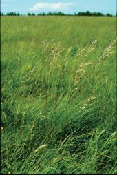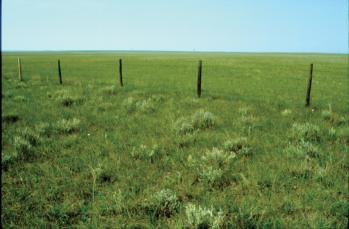
The native grasslands of Saskatchewan are part of the Grassland Biome that once stretched from the prairie provinces as far south as Mexico. These grasslands developed under the influence of major interacting forces: climate, fire, and large grazing animals. The typical grassland climate is characterized by a strong early summer peak in precipitation, a pronounced moisture deficit in late summer, precipitation/evaporation ratios of less than 1.0, and periodic droughts. In Saskatchewan, grassland composition changes in moving from the relatively hot, dry southwest to the northeast, which has similar precipitation but lower temperatures and less evaporation. The typical soil that developed under grassland vegetation is the Chernozem type, with organic matter accumulation in the black or brown A horizon. Grassland ecosystems are composed of plant communities, along with animals, micro-organisms, and environmental factors, all of which interact. Grassland plant communities are dominated by grasses and graminoids (grass-like plants such as sedges). Trees are absent from climatically determined grassland (steppe), but small shrubs (half-shrubs) can be common. Non-graminoid herbaceous plants (forbs) are also present in grasslands, and sometimes are seasonally dominant. Prairie is a term generally considered synonymous with grassland. Parkland is a mixture of grassland and scattered clumps of trees that occurs in the transitional region between grassland and forest.

The first written description of Saskatchewan grassland is that of Henry Kelsey, an employee of the Hudson’s Bay Company who traveled from York Factory as far inland as the Canadian prairies in 1690 and 1691. Passages from his journal, some written in rhyme, describe encounters with bison and plains grizzly bears. On August 20, 1691, he wrote: “Today we pitcht to ye outermost Edge of ye woods. This plain affords Nothing but short round sticky grass a Buffillo & a great sort of Bear wch is Bigger than any white bear & is Neither White nor Black But silver haired…” Fur trade post journals made frequent reference to wildfires in the grasslands, and to the large number of bison and other wildlife species. For example, October 30, 1836, at Carlton House: “Indians indicate that plains are burnt to a very great extent and that buffalo are very far off.” Captain John Palliser (see Palliser and Hind Expeditions), exploring the Canadian prairies in 1857–59, described the region as “bare and arid, with the herbage of the plains nearly worthless, and buffalo very numerous, and have eaten the grass down considerably, and have not left much for the horses.” Although these early descriptions of the grassland region provide evidence of the important role played by fire, climate and grazing, the scientific study of grasslands did not begin until the 20th century, with the development of the discipline of ecology.
Some of the earliest work on grassland ecology in Saskatchewan was done by Robert T. Couplan, professor of Plant Ecology at the University of Saskatchewan (1948–2002). His classification of the natural grasslands of the prairie provinces remains in widespread use. He directed the Matador Project (1967–72), which involved an interdisciplinary team of ecologists and other scientists working under the International Biological Programme, and analysed the structure and functioning of a grassland ecosystem east of Kyle, Saskatchewan. Coupland continued to contribute to the understanding of grassland ecosystems in Canada and abroad well into the 1990s.
Grasses have growing buds located at or just below the soil surface, protecting them from removal by grazing animals and fire, and from desiccation. Grasses are classified by height: short grasses (< 0.3 m), mid-grasses (0.3-1.0 m), and tall grasses (>1.0 m). They are also separated on the basis of growth habit into perennial bunchgrasses, perennial sod-forming grasses, and annual grasses. Species differ in the optimum temperature for plant processes such as photosynthesis. Warm-season grass species do best at temperatures about 10°C higher than cool-season species, and therefore grow during the warmer part of the growing season, or on warmer sites within the landscape (e.g., south-facing hillsides). Each plant species in a grassland community fits into a particular niche (i.e., it has its own place in time, space or functional relationships relative to other species). A single grassland community can have as many as two dozen plant species. Grassland plant species have well-developed root systems. Up to 80% of the plant biomass (weight of material produced by plants) is found below ground. The biomass of consumer and decomposer organisms is also concentrated below ground: much of the structure and functioning of grassland ecosystems is therefore hidden away beneath the soil surface. Species in the same community can have different niches, based on depth of rooting: some species have roots as deep as two metres, others have roots concentrated near the surface.
Grassland climate and vegetation favour fire. Plant growth during moist parts of the growing season produces herbage growth that dies back during dry periods, yielding a fine fuel. Before settlement the area of continuous flammable vegetation could be huge, especially during late summer and fall, as well as in dry years. Thunderstorms, sometimes with “dry” lightning (a large number of strikes, but low precipitation) ignited fires. There was also deliberate burning by Aboriginal peoples to improve grassland for forage or to drive game. Some grasses are more sensitive to fire than others: rough fescue, for instance, is sensitive because its buds are located higher than most grass species. Burning reduces the cover of woody species, which have their buds well above ground. In moister grasslands, fire can increase primary productivity by destroying heavy cover of dead plant residue (litter or mulch). In some cases, burning increases forb cover by removing excess mulch. Fire produces a fertilizer effect in some communities by releasing nutrients tied up in litter, and by producing conditions favourable for nitrification. Fire also has negative effects. Although most mineral nutrients are deposited in the ash, nitrogen compounds are subject to distillation and loss at temperatures reached during the fire. Fire can lower the water infiltration into soils due to the removal of litter and humus, and thus increase runoff and erosion. Burned sites have higher soil temperatures because the blackened surface absorbs radiation. Removal of the litter layer leads to drying of the soil surface. Burned sites have reduced snow-trapping in winter, and this also causes drier soil conditions.
Mixed Prairie is the largest grassland association in Saskatchewan and in North America. It extends from the prairie provinces to Texas, between Tall Grass Prairie in the east and the Rocky Mountains in the west. In western Canada it is bordered on the north by Aspen Parkland and Fescue Prairie. Mixed grassland is drier than Tall Grass Prairie and Fescue Prairie. The major proportion of precipitation comes in spring and early summer; late-season drought is typical. Mid-grasses dominate in wet periods of climatic cycles, short grasses in dry periods (the mixture of short and mid-grasses gives Mixed Prairie its name). Grazing also causes Mixed Grassland to shift toward dominance by shorter grasses and other species that increase with grazing (e.g., pasture sage, Artemisia frigida). There is often strong variation in species composition over the landscape, depending on topography, slope position, and substrate. Dozens of forb species, many with attractive flowers, can be found throughout the Grassland; prairie crocus (Anemone patens) is a favourite early-spring forb.
The composition of Mixed Grassland in Saskatchewan changes from the moister northeast to the drier southwest. Moist Mixed Grassland on loamy soil is dominated by northern wheatgrass (Agropyron dasystachyum) and western porcupine grass (Stipa spartea var. curtiseta). To the southwest, dominance of the grassland community shifts to needle-and-thread (Stipa comata), blue grama (Bouteloua gracilis), and western wheatgrass (Agropyron smithii). A mat of low clubmoss (Selaginella densa) is typical of dry Mixed Prairie. The driest part of the Mixed Prairie is found north and south of the Cypress Hills. Grasslands in sandhills, located in several parts of the province, are dominated by needle-and-thread, blue grama, and sand reed grass (Calamovilfa longifolia). Clayey soils like those on the Regina Plain and in the Rosetown-Elrose district support a distinctive grassland made up of northern wheatgrass and Junegrass (Koeleria macrantha). This grassland type has virtually disappeared because of widespread cultivation.
Fescue Prairie extends from the eastern foothills of the Rocky Mountains through central Alberta and Saskatchewan. It is also prominent at elevations above Mixed Prairie in the Cypress Hills. Fescue Prairie is the most typically Canadian of all the grassland associations, with only limited distribution in the United States. The climate is cooler and moister than in Mixed Prairie, and the ratio of precipitation to evaporation is relatively low: for example, the precipitation/evaporation ratio at Saskatoon (northern edge of the Mixed Prairie) is 0.35; at Prince Albert (in the Parkland) it is 0.65. The dominant grass in Fescue Prairie in Saskatchewan is plains rough fescue (Festuca hallii), which has a weaker bunch growth habit than mountain rough fescue (Festuca campestris), which occurs in the Rocky Mountain foothills. Common associates are awned wheatgrass (Agropyron subsecundum), western porcupine grass (Stipa spartea var. curtiseta), and Hooker’s oatgrass (Helictotrichon hookerii). Idaho fescue (Festuca idahoensis), timber oatgrass (Danthonia intermedia), and shrubby cinquefoil (Potentilla fruticosa) are associates in the Cypress Hills; slender wheatgrass (Agropyron brachycaulum), mat muhly (Muhlenbergia richardsonis), and sedges (Carex stenophylla and C. pensylvanica) are associated species in the Parklands. The diversity of forb species can be very high. Aspen (Populus tremuloides) forms groves, usually around wet depressions in the landscape.
Human settlement, particularly agricultural cultivation starting in the late 1800s, drastically reduced the area of natural grasslands in Saskatchewan. Even prior to this, over-hunting of large herbivores like the bison as well as other human activities had started the disintegration of the Grassland Biome. The Fescue Prairie has been reduced to less than 5% of its original area; only about 25% of the original Mixed Prairie of Saskatchewan survives today. Nearly all grassland on arable soils has been ploughed up: the wheatgrass-Junegrass type, for example, has been almost obliterated. Most remaining grasslands are in hilly terrain and on sandy, rocky or saline soils that are unsuitable for cultivation. Relatively large areas of native grassland can still be found in southwestern Saskatchewan, notably in Grasslands National Park and the Cypress Hills. Many parks, wildlife refuges, community pastures, and ecological reserves, as well as private land throughout the province contain native grasslands. Restoration ecologists are improving their ability to re-establish native grassland species in areas where the original grassland has been destroyed. Natural grasslands are important economically for grazing by domestic livestock, as wildlife habitat, and for the preservation of species diversity. The discipline of range management aims at balancing grazing and other uses of native grasslands in order to maintain grassland health and productivity. The complete exclusion of grazing and fire can lead to excessive litter build-up and cause the degradation of grassland. The invasion of exotic plant species such as brome grass (Bromus inermis) is another threat. Grassland conservation efforts like the Prairie Conservation Action Plan have expanded greatly in recent years as people appreciate more fully the value of their natural grassland heritage.
Robert E. Redmann