Welcome to the Encyclopedia of Saskatchewan. For assistance in exploring this site, please click here.
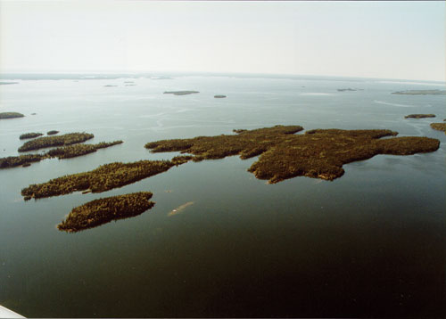
(55°15’ 104°45’; Map sheet 73 P/2). Lac la Ronge covers 1,414 sq. km and lies at an elevation of 364 m. It is located on the southern margin of the Shield, served by Hwy 2 and, north of the town of La Ronge, by Hwy 102. Most of the rugged shoreline and numerous islands that lie within the Shield form part of Lac la Ronge Provincial Park. The southern shore, south of the Shield margin, is much less rugged. Lac la Ronge probably derived its name from the French verb ronger “to gnaw.” Certainly, the lake was a centre for a Fur Trade based largely on beaver pelts. In the winter of 1781–82 there were two trade posts on the lake, one established by Peter Pond and the other by Jean-Étienne Wadin. The two quarrelled,and Wadin was fatally shot. In spite of this, the fur trade continued, a tradition maintained into the latter half of the 20th century by Robertson’s Trading Post in La Ronge. A number of small First Nation reserves are located around the shore, while the main service centre for the region is the town of La Ronge (pop. 2,727). Tourism based on camping, fishing, hunting and boating provides a significant source of income for the town.
Marilyn Lewry
Print EntryHOME | BROWSE BY SUBJECT | ENTRY LIST (A-Z) | IMAGE INDEX | CONTRIBUTOR INDEX | ABOUT THE ENCYCLOPEDIA | SPONSORS TERMS OF USE | COPYRIGHT © 2006 CANADIAN PLAINS RESEARCH CENTER, UNIVERSITY OF REGINA | POWERED BY MERCURY CMS |
|||
| This web site was produced with financial assistance provided by Western Economic Diversification Canada and the Government of Saskatchewan. |
|||
| Ce site Web a été conçu grâce à l'aide financière de Diversification de l'économie de l'Ouest Canada et le gouvernement de la Saskatchewan. |
|||