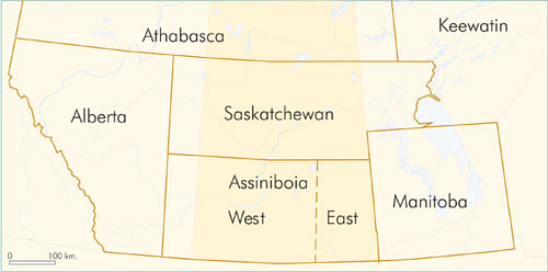
Figure BSK-1: Provisional Districts.
The Boundary Survey Trail in Saskatchewan was established in 1873-74. The trail was used by both the Dominion and American governments to survey accurately the international boundary (49th parallel) as determined by the London Convention of 1818. The Canadian government commissioned the legal survey after acquiring Rupert’s Land (see Rupert’s Land Purchase) from the Hudson’s Bay Company in 1870. The Boundary Commissioners, consisting of Canadian and American surveyors, first met in Pembina, North Dakota in September 1872. After spending the first winter near Willow Bunch, the party left its winter post in the spring of 1874 and headed for Waterton Lake, where a boundary marker signifying the end of the Pacific-Rocky Mountains survey was already erected. On August 8, 1874, the boundary commission party reached Waterton Lake, erecting the last boundary marker and completing the difficult task of legally surveying the border between Canada and the United States.
James Winkel